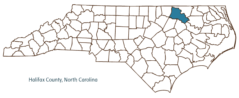
Halifax County Resources
- View All:
- Biographies
- Monuments
- locations
Copyright Notice: This article is from the Encyclopedia of North Carolina edited by William S. Powell. Copyright © 2006 by the University of North Carolina Press. Used by permission of the publisher. For personal use and not for further distribution. Please submit permission requests for other use directly to the publisher.

Halifax County, located in North Carolina's Coastal Plain region (on the fall line between the coastal plain and the piedmont), was formed from Edgecombe County in 1758. Its name is derived from George Montague, second earl of Halifax and president of the British Board of Trade and Plantations. The county seat, also named Halifax, had been established in 1757; other Halifax County communities include Roanoke Rapids, Weldon, Littleton, Enfield, Scotland Neck and Hobgood.
Originally home to Tuscarora Indians, the area was settled in the early eighteenth century by English colonists migrating south from Virginia. Slave-driven plantations soon emerged to take advantage of the fertile soil. The town of Halifax developed along the banks of the Roanoke River and established itself as the trading hub for goods passing from settlement to settlement. However, the prosperity Halifax County enjoyed came to an end with the rise of the railroads, which diminished the importance of rivers for freight transportation, and the abolition of slavery, which brought the age of the wealthy plantation owner to an end. Remnants of an antebellum canal and aqueduct can be seen at Roanoke Rapids.
On 12 Apr. 1776, the North Carolina Provincial Congress met in Halifax and unanimously passed a resolution later known as the Halifax Resolves. The first resolution of its kind, the document instructed North Carolina's delegates to the Second Continental Congress in Philadelphia to vote for independence from Great Britain. The date of the Halifax Resolves is commemorated on the state's flag, and 12 April is celebrated each year as Halifax Day in the county, with individuals in period costumes demonstrating colonial-era activities and craftsmanship. The Historic Halifax State Historic Site interprets these events.
Halifax County natural attractions include Medoc Mountain State Park, Lake Gaston, and Roanoke Rapids Lake. The Lakeland Arts Center, the Canal Arts Center, and the Roanoke Valley Players theater group are a few of the county's cultural institutions. Agricultural and manufacturing products include tobacco, peanuts, cotton, corn, textiles, paper, and apparel. In 2004 the estimated population of Halifax County was 56,400.
For an annotated history of the county's formation, with the laws affecting the county, boundary lines and changes, and other origin information, visit these references in The Formation of the North Carolina Counties (Corbitt, 2000), available online at North Carolina Digital Collections (note, there may be additional items of interest for the county not listed here):
County formation history: https://digital.ncdcr.gov/Documents/Detail/the-formation-of-the-north-ca...
Index entry for the county: https://digital.ncdcr.gov/Documents/Detail/the-formation-of-the-north-ca...
References:
W. C. Allen, History of Halifax County (1993).
Additional resources:
Corbitt, David Leroy. 2000. The formation of the North Carolina counties, 1663-1943. https://digital.ncdcr.gov/Documents/Detail/the-formation-of-the-north-carolina-counties-1663-1943/3692099?item=4553233 (accessed June 20, 2017).
Halifax County Government: https://www.halifaxnc.com/
Roanoke Valley Chamber of Commerce: https://www.rvchamber.com/
DigitalNC, Halifax County: https://www.digitalnc.org/counties/halifax-county/
North Carolina Digital Collections (explore by place, time period, format): https://digital.ncdcr.gov
Image credits:
Rudersdorf, Amy. 2010. "NC County Maps." Government & Heritage Library, State Library of North Carolina.
Vocci, Robert Blair. "Halifax County." NCpedia. State Library of NC. 2006. https://www.ncpedia.org/geography/halifax.
HALIFAX COUNTY GOVERNMENT:
https://www.halifaxnc.com/
COUNTY SEAT: Halifax
FORMED: 1758
FORMED FROM: Edgecombe
LAND AREA: 724.09 square miles
2020 POPULATION ESTIMATE: 48,622
White: 39.9%
Black/African American: 53.8%
American Indian: 4.1%
Asian: 0.9%
Pacific Islander: 0.1%
Two or more races: 1.3%
Hispanic/Latino: 3.1% (of any race)
From State & County QuickFacts, US Census Bureau, 2020.
CONGRESSIONAL DISTRICT: 1ST
BIOGRAPHIES FOR![]()
Halifax County
 WILDLIFE PROFILES FOR
Coastal Plain
GEOGRAPHIC INFORMATION
REGION: Coastal Plain
RIVER BASIN: Roanoke, Tar-Pamlico, Map
NEIGHBORING COUNTIES: Bertie, Edgecombe, Martin, Nash, Northampton, Warren