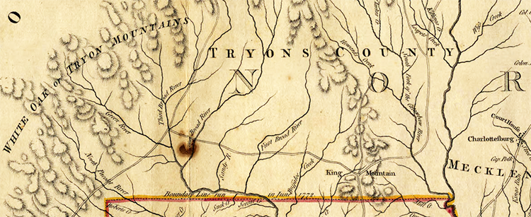
Tryon County Resources
- View All:
- Biographies
- Monuments
- locations
ANCHOR (A North Carolina History Online Resource) will soon have its own website!
We are setting up redirects so links to current ANCHOR pages on NCpedia will send users to the new site in the future.
In 1768, the Colonial Assembly acted upon the entreaties of Mecklenburg County citizens who complained about having to travel long distances to the county court as a result of the county’s immense size. The decision was made to divide Mecklenburg County into two separate counties: Mecklenburg and Tryon. The latter was named for Governor William Tryon who had replaced the previous governor, Arthur Dobbs, in 1765.

The legislative act establishing Tryon County did not take effect until April 10, 1769. The first county courthouse was located on land in what is today Gaston County. In August 1775, four months after the Battle of Lexington, Massachusetts, 49 Tryon County citizens signed the Tryon Resolves proclaiming their defiance of the British government and resolution to follow the orders of the Continental Congress. The following month the county officially began forming militia companies for Patriot service.
In 1779, the General Assembly voted to do away with Tryon County, dividing the land into Lincoln and Rutherford Counties. Tryon was serving as a British officer at the time, and citizens desperately wanted the county name changed to reflect their Patriotic sentiments. Lincoln County was named for Major General Benjamin Lincoln of the Continental Army while Rutherford was named for North Carolina militia leader Griffith Rutherford. In 1846, Lincoln County was divided, and a portion of what had once been Tryon County became Gaston County, named for U.S. Congressman and jurist William Gaston.
Tryon holds the distinction of being one of four counties whose names were changed during the Revolutionary and early national period. The others include Dobbs County, formerly named for Arthur Dobbs, which became in 1779 Wayne and Lenoir Counties; Bute County, named for the Earl of Bute, divided in 1779 to form Franklin and Warren Counties; and Glasgow County, named for James Glasgow, which became in 1799 Greene County.
References:
Clarence W. Griffin, History of Old Tryon and Rutherford Counties, North Carolina, 1730-1936 (1937)
David L. Corbitt, The Formation of the North Carolina Counties, 1663-1943 (1950)
Kathy G. Sullivan, Tryon County Documents, 1769-1779 (2000)
Walter Clark, ed., State Records of North Carolina, XXIII-XXIV
William S. Powell, ed., Encyclopedia of North Carolina (2006)
Image Credits:
Mouzon, Henry. "An Accurate Map of North and South Carolina With Their Indian Frontiers, Shewing in a distinct manner all the Mountains, Rivers, Swamps, Marshes, Bays, Creeks, Harbours, Sandbanks and Soundings on the Coasts, with The Roads and Indian Paths; as well as The Boundary or Provincial Lines, The Several Townships and other divisions of the Land in Both the Provinces; the whole from Actual Surveys by Henry Mouzon and Others." London: Robt. Sayer and J. Bennett, Map and Print-Sellers. 1775. North Carolina Maps. https://dc.lib.unc.edu/cdm/singleitem/collection/ncmaps/id/125/rec/55 (accessed June 7, 2013).
Hill, Michael. "Tryon County." NCpedia. State Library of NC. 2008. https://www.ncpedia.org/tryon-county.