Sampson County Resources
- View All:
- Biographies
- Monuments
- locations
Copyright Notice: This article is from the Encyclopedia of North Carolina edited by William S. Powell. Copyright © 2006 by the University of North Carolina Press. Used by permission of the publisher. For personal use and not for further distribution. Please submit permission requests for other use directly to the publisher.

See also: Hollerin' Contest.
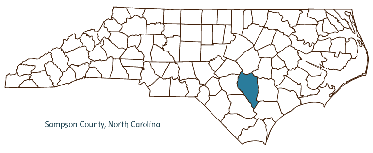
Sampson County, located in the Coastal Plain region of North Carolina, was formed in 1784 from Duplin County and was named for Col. John Sampson, a member of the North Carolina House of Commons. Early inhabitants of the area included the Coharie Indians, followed by English, Welsh, and Scottish settlers. Clinton, the county seat, was incorporated in 1822 and was named after Richard Clinton, the foster son of John Sampson, the original owner of the land on which the town was built. Other communities in the county include Newton Grove, Suttontown, Turkey, Elliott, Harrells, Tomahawk, Parkersburg, Garland, and Keener. The Black River, Warrens Pond, Mingo and Starling Swamps, Dismal Bay, and Turkey and Wild Cat Creeks are a few of the county's significant physical features.
Notable among Sampson County's historic sites and landmarks are the Clinton Depot and Freight Station (ca. 1920); the Graves-Stuart House, built in the 1840s; the Archibald Monk House, built around 1824; and Thirteen Oaks, built in 1902. Cultural institutions include the Community Theatre Group, the Dr. Victor R. Small Cultural Arts Center, and the Sampson County History Museum. The county hosts festivals and annual events such as the National Hollerin' Contest in Spivey's Corner, the Fireman's Day Parade and Festival, the Sweet Potato Festival, and the Rotary Fair and Parade.
Sampson County produces agricultural goods such as tobacco, vegetables, cotton, corn, soybeans, swine, and poultry. Manufactured goods include lumber and lumber products, furniture, apparel, and animal feeds. The estimated population of Sampson County was 62,600 in 2004.
For an annotated history of the county's formation, with the laws affecting the county, boundary lines and changes, and other origin information, visit these references in The Formation of the North Carolina Counties (Corbitt, 2000), available online at North Carolina Digital Collections (note, there may be additional items of interest for the county not listed here):
County formation history: https://digital.ncdcr.gov/Documents/Detail/the-formation-of-the-north-ca...
Index entry for the county: https://digital.ncdcr.gov/Documents/Detail/the-formation-of-the-north-ca...
References:
Tom Butchko, An Inventory of Architecture of Sampson County, North Carolina (1979).
Additional resources:
Corbitt, David Leroy. 2000. The formation of the North Carolina counties, 1663-1943. https://digital.ncdcr.gov/Documents/Detail/the-formation-of-the-north-carolina-counties-1663-1943/3692099?item=4553233 (accessed June 20, 2017).
Sampson County Government: https://www.sampsonnc.com/
Clinton Sampson Chamber of Commerce: https://www.clintonsampsonchamber.org/
Sampson County resources, NC Digital Heritage Center: https://www.digitalnc.org/counties/sampson-county/
North Carolina Digital Collections (explore by place, time period, format): https://digital.ncdcr.gov
Image credits:
Rudersdorf, Amy. 2010. "NC County Maps." Government & Heritage Library, State Library of North Carolina.
Mazzocchi, Jay. "Sampson County." NCpedia. State Library of NC. March 2025. https://www.ncpedia.org/geography/sampson.