C.J. Sauthier was a French illustrator, draftsman, and cartographer. He specialized in landscaping and architecture and wrote a book in 1763, A Treatis on Public Architecture and Garden Planning, which was very popular.
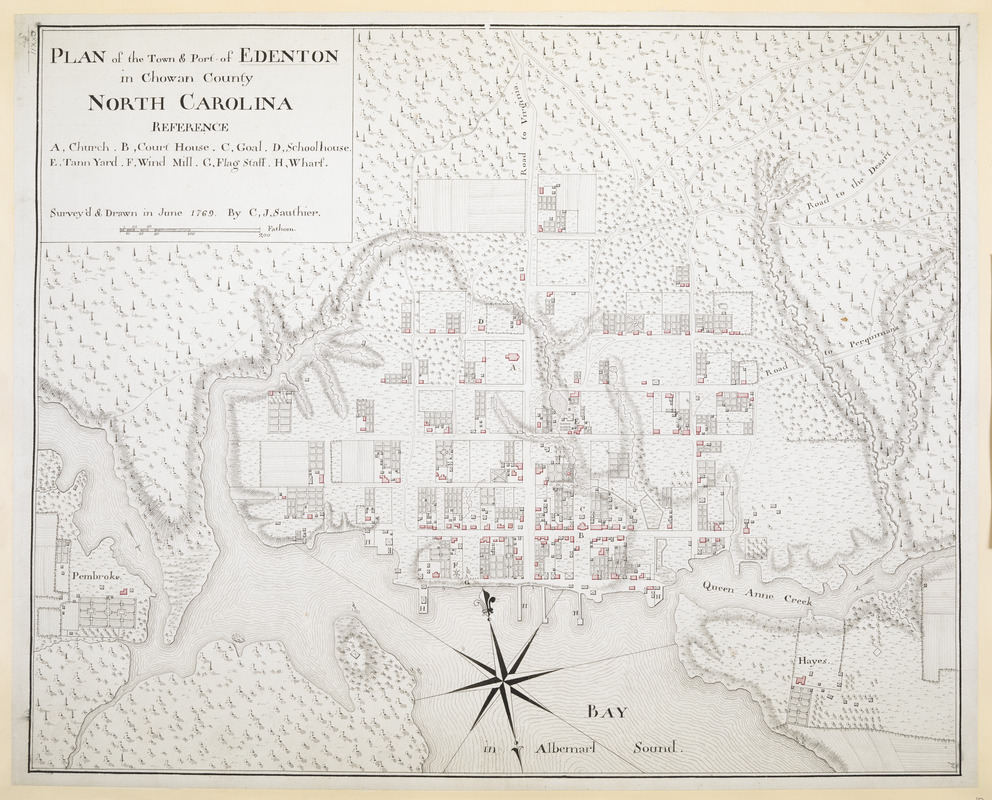
In 1767, Governor William Tryon invited Sauthier to come to North Carolina. Tryon wanted to map towns and ports that had strategic potential in case of war. In addition to making this map of Edenton, Sauthier made maps of Halifax, New Bern, and Wilmington. When Tryon was made governor of New York, Sauthier went with him to make maps in the colony of New York.
During the war for American Independence, Sauthier worked for the British. At the end of the War, Sauthier moved to Britain.
Interpreting historical maps
Historical maps can help us understand a number of things about everyday life in colonial villages. Looking at the map and using the information provided above, see if you can answer some of these questions:
- We know that the Royal Governor of North Carolina asked Sauthier to make this map as part of a larger project to map cities that had a strategic military purpose. Why do you think Edenton would have been one of the cities the governor wanted mapped? What would make it a useful town during a war?
- How many roads lead in to town? Would this make it easier or more difficult to defend Edenton? What other factors would you consider if you were in charge of protecting this town?
- Notice what buildings Sauthier labeled on this map: He has labeled the church, court house, goal (jail), school house, tan yard, flag staff, and wharf.
- Why do you suppose these buildings were labeled while other buildings were not?
- Look at the labeled buildings: Which ones are close to each other? Why do you suppose this is the case? How does this help us understand the way community life was organized in colonial North Carolina?
- If you were making a map, what other buildings would you include? Why?
- Look at the layout of the houses and fields. Why do you suppose there was so much land surrounding the houses?
- How are the houses situated in relation to the rivers, creeks, and ocean?
- How many streets are there? What do they connect?
- If you wanted to move something from the wharfs to the school or the church, how difficult do you think it would be? What about from the tan yard to the wharf? What obstacles would be in your way?
- Which house would you choose to live in and why? What is nearby that would make it a good choice? Which part of town would you not want to live in and why?