Early European travelers to the Americas reported bits and pieces of information back to Europe. Over the centuries, mapmakers assembled these reports into maps. As time went by, explorers and mapmakers compiled an increasingly accurate understanding of the Americas and of the world. To do so, they had to invent new tools for mapmaking, embrace radical new ideas about the shape of the world, and discard cherished beliefs.
An old story tells of a group of blind men encountering an elephant. The first man feels the elephant's trunk and announces that the strange animal is a snake. The second man feels the elephant's leg and decides that it must be a tree. Another feels the tusk and says the elephant is like a pipe, while still another feels its belly and declares it a wall.
Each of the blind men was wrong, of course -- and yet each of them had a piece of the truth, and by assembling all of their pieces, they could create an accurate picture of an elephant.
Early European travelers to the Americas were like these blind men, exploring portions of the continent and reporting bits and pieces of information back to Europe. Over the centuries, mapmakers assembled these reports into maps that could be used for navigation on the open seas, to direct ships to newly discovered lands, and to control the lands they claimed.
Over time, explorers and mapmakers compiled an increasingly accurate understanding of the Americas and of the world. To do so, they had to invent new tools for mapmaking, embrace radical new ideas about the shape of the world, and discard cherished beliefs. The story of European exploration of the world is as much a story of science, mathematics, and art as of heroism and bravery.
The science of cartography
The key problem in cartography -- the science of mapping -- is that the earth is a sphere, but a piece of paper is flat. If you could peel off the face of the earth like the skin of an apple and press it flat, it wouldn't make a rectangle, or a circle, or an oval -- or any simple, contiguous shape. The cartographer's challenge is to determine how to represent the spherical surface of the earth on a flat map while preserving key information about it.
The Greek mathematician Ptolemy (90-168 CE) was the first to develop a map using lines of latitude and longitude and defining locations on a coordinate system. Islamic mapmakers in the Middle Ages built on his ideas, and the Chinese also drew coordinate-based maps to careful scale. But European maps represented the earth symbolically and were drawn based on religion and philosophy, not exploration and accurate mathematics. Only when Europeans discovered the Americas and wanted to exploit the wealth of the new lands did they find a need to treat mapmaking more scientifically.
An ideal map should correspond to the earth's surface in several ways:
- The sizes of regions on the map should be proportional to their sizes on the earth's surface.
- The shapes of regions on the map should resemble their shapes on the earth's surface.
- Distances between points on the map should be proportional to the distances between those points on the earth's surface.
- The map should be contiguous -- there shouldn't be any interruptions in it. Just as any two points on the earth's surface can be connected by a line, someone should be able to draw a line between any two points on the map.
The problem is that achieving all four of these goals is only possible if you make a globe. How to make a flat map that accurately represents the earth's features?
The Mercator projection
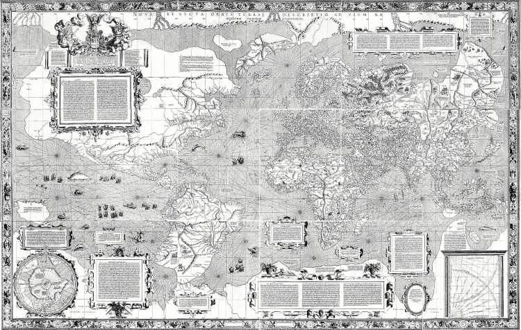
In 1569, the Flemish geographer and cartographer Gerardus Mercator created a map using a mathematical formula to "project" points on the earth's surface onto a map based on their latitude and longitude. His formula -- called the Mercator projection -- became the standard means of making maps for navigation, because the directions of the compass corresponded to directions on the map. North, east, south, and west were straight lines on paper, just as they are on the earth's surface.
The problem with the Mercator projection is that it distorts areas and distances. The North and South Poles are stretched all the way across the top and bottom of the map, and regions to the far north and south appear much larger than they actually are. This isn't a problem for navigation -- Google Maps uses a Mercator projection even today -- and the distortion is negligible for small maps (say, of North Carolina). But it can give a false impression of the relative sizes of various countries and continents. For example, Greenland is larger than Africa! Cartographers have developed a number of other projections with various advantages and disadvantages, but the Mercator projection is the vision of the earth that most of us have in our heads more than four centuries later.
For sixteenth-century sailors and mapmakers, the problem with the Mercator projection was that it was ahead of its time technologically. You'll note that Mercator's map, despite its careful mathematics, isn't very accurate -- because explorers didn't know where they were! As a result, they couldn't report accurate information about the features of the lands they explored, and they couldn't use a Mercator-projection map effectively for navigation. For maps to become really useful, three problems had to be solved: sailors needed to be able to determine their direction, their latitude, and their longitude to a great degree of accuracy.
Finding a way on the seas
The first people to venture out to sea in boats stayed close to shore and navigated by landmarks. Once in the open ocean, though, they had to invent ways of determining where they were and what direction they were headed.
Direction
The magnetic compass was invented in China in the eleventh century, but was first used for navigation by Europeans in the thirteenth century. Until that time, direction at sea could be determined only by the position of the sun and stars -- making navigation impossible if the weather was poor. At first, the compass was only a magnetized pointer floating in a bowl of water. By about 1300, the "dry compass" was in use -- a free-floating pointer in a closed box, with a "wind rose" showing the cardinal directions of north, south, east, and west.
But magnetic north isn't true north -- the north magnetic pole of the earth is not the geographic north pole. Worse, the earth's magnetic field is constantly changing, and deposits of iron ore can throw off compass readings. The difference between magnetic north and true north is called magnetic declination or magnetic variation. The first charts of magnetic declination were not developed until the early eighteenth century, and only then did the magnetic compass become a reliable tool for navigation on the open sea.
Latitude
The sun and constellations follow a specific path through the sky that changes with the time of year and the observer's distance from the equator, or latitude. By measuring the angle of certain stars above the horizon, an experienced navigator could determine his latitude. In the northern hemisphere, Polaris, the "North Star," is the best star by which to navigate, because it is circumpolar -- it is in a direct line with the earth's axis, above the North Pole. As a result, it always appears due north in the sky, and its angle above the horizon is the same as the observer's degree of latitude. Mariners could also measure the altitude of the sun at noon to determine their latitude.
The ancient Phoenecians (about 1000 BCE) had sufficient understanding of astronomy to navigate by the stars, but measuring the altitude of a star was difficult. By the time Europeans began exploring the world, several tools were in use to aid in sighting stars.
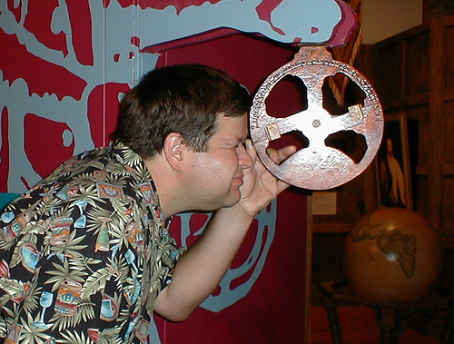
- The simplest tool was the cross-staff, which had two arms, one to be pointed at the horizon and one to be pointed at a star or the sun. The angle between the two arms gave the altitude of the star. Because the navigator had to point one arm of the staff toward the horizon manually, errors were common.
- The astrolabe, invented by the Greeks in the first or second century CE and used by Europeans for navigation in the fifteenth and sixteenth centuries, was a simple brass ring, graduated in degrees, with a rotating arm for sighting the sun or a star. It was designed to be suspended from a ring so that it would hang vertically and clearly show the direction of the horizon. it But the astrolabe was hard to stabilize on a rocking ship, and errors of four to five degrees were common -- quite a lot, when you consider that there are only about thirty degrees of latitude between London and the Caribbean!
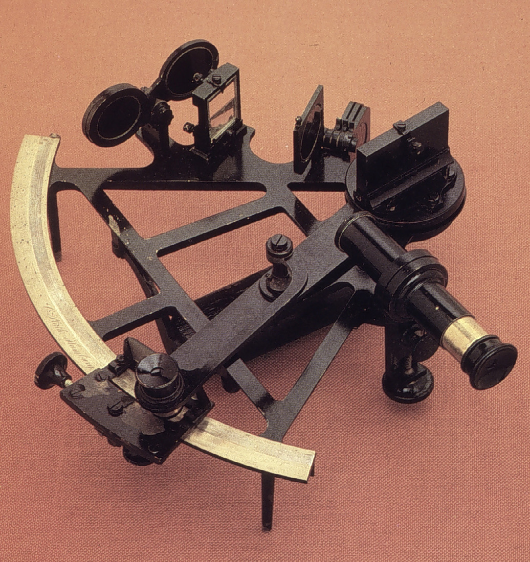
- The sextant, invented around 1730, uses a pair of mirrors to sight the horizon and the sun or a star. The use of mirrors compensates for the motion of the ship, and makes the sextant accurate to 10 seconds of latitude -- about 1,000 feet.
Latitude and longitude are measured in degrees, with 360 degrees in a circle. For more precision, there are 60 minutes in a degree and 60 seconds in a minute. A degree of latitude is approximately 69 miles, and a minute of latitude is approximately 1.15 miles. A second of latitude is approximately 0.02 miles, or just over 100 feet.
Longitude
Longitude was another matter. For a long time, there was no way to determine longitude -- the distance a ship had traveled east to west. Sailors had to calculate how far east or west they had sailed by measuring the ship's speed, then multiplying by the time they had been traveling. Since they knew their change in latitude, and the total distance they had traveled, they could calculate their longitude.
The problem was that until the late eighteenth century, portable clocks were not accurate enough to make precise calculations possible. Even the best clocks of the time probably lost 10 minutes a day, which added up quickly on a long sea voyage. The search for a way to measure longitude was really a search for a way to measure time.
Measuring speed was hard enough. Originally, sailors used "dead reckoning" -- they simply estimated their speed and distance traveled based on experience. In the sixteenth century the chip log, a crude speedometer, was invented. Sailors tied knots at regular intervals in a lightweight rope, tied a weight to the end so it would drag in the water, and tossed the end overboard. The pilot counted the knotsa knot is defined today as one nautical mile per hour. A nautical mile is slightly larger than a mile, and corresponds roughly to one minute of latitude. that were let out during a specific period of time, and this told him how fast the ship was moving. (The speed of a ship on water is still referred to as "knots"!)
The most accurate way to determine longitude was to keep a clock set to the time at home port, then note what time solar noon occurred on that clock. At noon at any point on the earth's surface, the sun will reach its maximum altitude -- something sailors could easily note (assuming the sky wasn't cloudy). If local noon occurred at 1 pm on their clock from home, for example, they knew they had traveled one "hour" west -- 1/24 of the way around the globe, or 15 degrees.
Measuring longitude was so important to trade that several nations offered prizes to the first person to invent a chronometer that could keep accurate time at sea. John Harrison, an Englishman, won the British prize in 1765 for a marine chronometer that was accurate to one-tenth of a second per day. When James Cook circumnavigated the globe in the 1770s, his calculations of longitude based on Harrrison's chronometer were accurate to within 8 miles!
Exploring and explaining new lands
In the 1500s, then, when Europeans set out to explore the Americas, they had neither sextants nor accurate chronometers, and their compasses' readings were often misleading. Their measurements of latitude were inaccurate, and their measurements of longitude were barely more than guesses. No wonder, then, that we would find their maps next to useless today!
How, then, did they find their way and make their maps? Like the blind men meeting the elephant, they had to feel their way around.
Signs of land
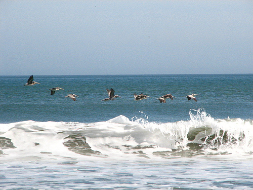
The first challenge at sea was simply finding land. From the journals of Columbus' first voyage, we can learn how sailors reckoned which direction land might lie, and how close by. (Often called the "Great Navigator," Columbus used dead reckoning, not celestial navigation, on his voyages. As a result, his measurements of latitude were consistently incorrect.) Birds normally seen near land, floating weeds, and weather could all be signs that land lay nearby -- often inaccurate signs, as the crew learned.
Sunday, 9 September. Sailed this day nineteen leaguesA league is an old measurement of distance, usually about three and a half miles. It originally meant the distance a man could walk in an hour's time, making it a useful measurement for land travel — if a highly variable one, since different people obviously walk at different paces. It was standardized in various times and places, but different people in different countries may have measured it differently. Columbus, as you can see from this entry in his journal, reckoned the league as four miles., and determined to count less than the true number, that the crew might not be dismayed if the voyage should prove long. In the night sailed one hundred and twenty miles, at the rate of ten miles an hour, which make thirty leagues. The sailors steered badly, causing the vessels to fall to leeward toward the northeast, for which the Admiral reprimanded them repeatedly.
Friday, 14 September. Steered this day and night west twenty leagues; reckoned somewhat less. The crew of the Nina stated that they had seen a grajaoPresumably a kind of seabird., and a tropic bird, or water-wagtail, which birds never go farther than twenty-five leagues from the land.v Sunday, 16 September. Sailed day and night, west thirty-nine leagues, and reckoned only thirty-six.... Here they began to meet with large patches of weeds very green, and which appeared to have been recently washed away from the land; on which account they all judged themselves to be near some island, though not a continent, according to the opinion of the Admiral, who says, "the continent we shall find further ahead."
19 September. Continued on, and sailed, day and night, twenty-five leagues, experiencing a calm. Wrote down twenty-two. This day at ten o'clock a pelican came on board, and in the evening another; these birds are not accustomed to go twenty leagues from land. It drizzled without wind, which is a sure sign of land. The Admiral was unwilling to remain here, beating about in search of land, but he held it for certain that there were islands to the north and south, which in fact was the case and he was sailing in the midst of them. His wish was to proceed on to the Indies, having such fair weather, for if it please God, as the Admiral says, we shall examine these parts upon our return. Here the pilots found their places upon the chart: the reckoning of the Nina made her four hundred and forty leagues distant from the CanariesThe Canary Islands are a Spanish possession off the northwest coast of Africa. They became an important port for sea traffic across the Atlantic., that of the Pinta four hundred and twenty, that of the Admiral four hundred.
8 October. Steered west-southwest and sailed day and night eleven or twelve leagues; at times during the night, fifteen miles an hour, if the account can be depended upon.... The weeds appeared very fresh. Many land birds, one of which they took, flying towards the southwest; also grajaos, ducks, and a pelican were seen.
Tuesday, 9 October. Sailed southwest five leagues, when the wind changed, and they stood west by north four leagues. Sailed in the whole day and night, twenty leagues and a half; reckoned to the crew seventeen. All night heard birds passing.
Thursday, 11 October. Steered west-southwest; and encountered a heavier sea than they had met with before in the whole voyage. Saw pardelasPardela is the Spanish name for petrels or shearwaters. Seabirds. and a green rush near the vessel. The crew of the Pinta saw a cane and a log; they also picked up a stick which appeared to have been carved with an iron tool, a piece of cane, a plant which grows on land, and a board. The crew of the Nina saw other signs of land, and a stalk loaded with rose berries.
1
Journals and reckoning
Once on land, explorers estimated their daily mileage on foot. Since a chip log didn't work on land, estimates of mileage were less accurate than on the ocean. Cartographers in Europe drew maps based on explorers' accounts, and you can imagine that if the account was not written clearly or with sufficient detail, the resulting map would have been nearly useless.
Sometimes a cartographer accompanied a voyage. An accomplished artist could draw a reasonable representation of a shoreline as he traveled along it, but he would be hampered by his inability to measure precisely where he was.
Imagining America
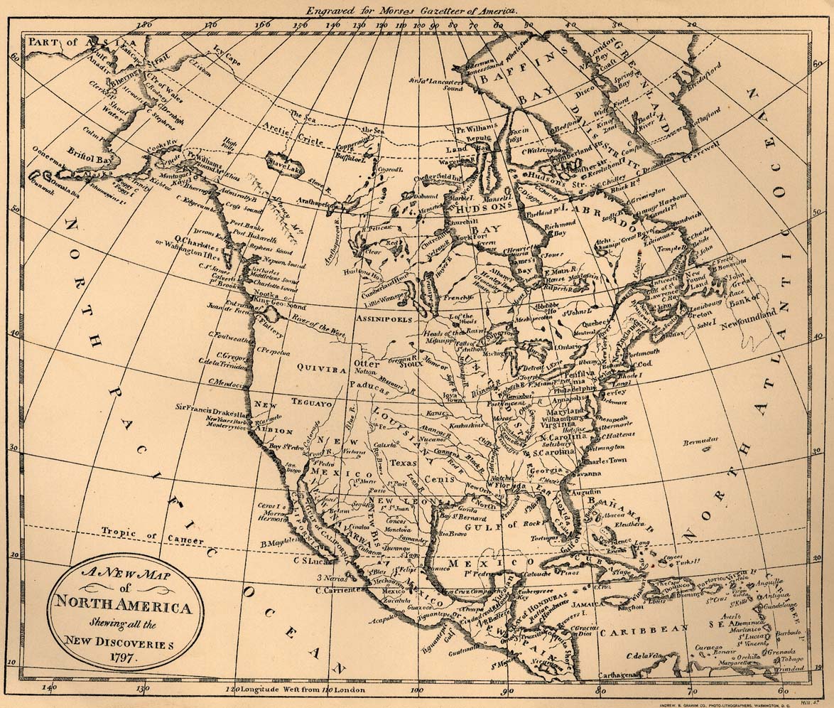
Given the difficulties faced by cartographers, it took hundreds of years, dozens of expeditions, and countless maps before an accurate picture of the North American continent emerged.
America, not Asia
Christopher Columbus and other early explorers believed they were reaching Asia when they struck land west of the Atlantic Ocean -- in part because they were unable to measure longitude, in part because they were uncertain how big Asia really was. Seeing only small islands, peninsulas, and short coastlines, they had no reason to think they were not in Southeast Asia and Indonesia.
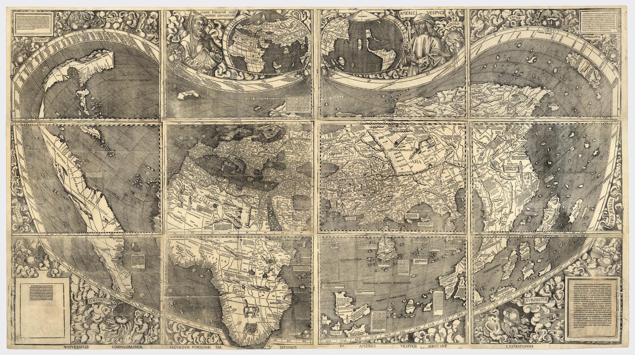
In 1499 and 1502, Amerigo Vespucci, an Italian merchant, accompanied two voyages that explored the east coast of South America. That continent, he discovered, extended much farther south than previously thought -- and much farther south than Asia. Accounts of his voyages attributed to him were published in Europe, and in 1507, Martin Waldseemüller produced a world map showing a new continent of "America."
Waldesmüller's map shows clearly the extent of Europeans' knowledge at this time. Look carefully for the lines of latitude, which are not straight -- remember, this is decades before Mercator -- but curve upward. The shapes of known landmasses are clearly recognizable. Europe and the Middle East look pretty good. Africa looks right, because Portuguese sailors had explored its entire coastline, though North Africa, which was better known, is bigger than it should be. Southeast Asia stretches too far south, though, and the islands of Indonesia are too large, too spread out, and difficult to identify if you're used to looking at modern maps.
America is the interesting part of this map. If you look closely, you can identify Florida, Cuba and the other islands of the Caribbean, the Yucatan Peninsula and the coast of Mexico, Panama, and the east coast of South America. As in Indonesia, the islands are drawn too large. Most of North America is a guess, or blank. And the continent is far too narrow: Europeans hadn't gotten very far inland yet. They didn't know how big America was, and they hadn't yet found the Pacific Ocean.
Where's the Pacific?
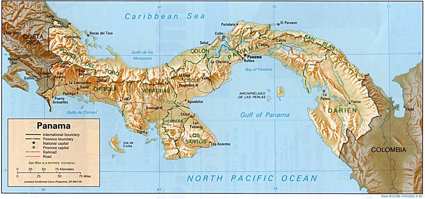
In 1513, Vasco Núñez De Balboa crossed the Isthmus of Panama, the thin strip of land that connects North and South America. The isthmus runs from east to west, and so Balboa's party traveled south across it. When he saw the Pacific Ocean on the other side, Balboa named it Mar del Sur, the South Sea, and claimed possession of both the ocean and all adjoining lands in the name of the Spanish crown.
What Europeans wanted, though -- despite the riches of the Americas -- was a sea route to Asia. In 1519 Ferdinand Magellan, a Portuguese explorer in the service of Spain, sailed west in an attempt to reach the Spice Islands of Indonesia. Reaching the Americas, he sailed south along the coast of South America until he found Cape Horn at the continent's southernmost tip. Near the Cape, a strait cuts through the tip of South America, and it is named the Strait of Magellan after him. He continued his journey northwest across the Pacific to the Philippines, where he was killed. His crew continued west, rounding the Cape of Good Hope at the southern tip of Africa, and the survivors returned to Spain three years after their departure, completing the first known circumnavigation of the globe. Their voyage of 43,400 miles gave Europeans a clearer sense of just how big the earth was.
It was now possible to sail west or east from Europe to reach Asia, but both routes required long voyages around southern continents. Was there an alternative?
The Northwest Passage
The English and French, eager for routes to Asia they could call their own, sent explorers to find a "northwest passage" around or through the North American continent. In 1497, John Cabot sailed in search of a westward route to Asia and landed in eastern Canada, thinking he had found the northeastern coast of Asia. In the late 1500s Martin Frobisher searched for a route around the north coast of North America, exploring the Canadian Arctic, but failed to find a navigable route.
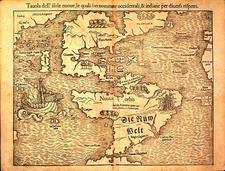
In 1524, Giovanni da Verrazano sailed for France in search of a northern route to the Pacific, and became the first European to explore the coast of North Carolina. He landed near Cape Fear, sailed south along the coast of South Carolina, then headed north again. Finding the Outer Banks, he thought that the water on the other side was open ocean -- surely, thought Verrazano, "the oriental sea between the west and north. Which is the one, without doubt, which goes about the extremity of India, China and Cathay [East Asia]." In fact he had discovered the Pamlico Sound, but back in Europe, mapmakers began to draw North America as being split by the "Sea of Verrazano", with a narrow land bridge on the east coast connecting the northern and southern parts. As late as 1651, a map of Virginia showed the Pacific Ocean as only a ten-day march away.
Explorations continued through the 1700s. Jacques Cartier explored the Saint Lawrence River in the sixteenth century, hoping it would lead to the Pacific. In 1609, Henry Hudson discovered the bay that bears his name and sailed up the Hudson River as far as Albany before giving up his search. Further explorations of the Canadian coast in the 1790s convinced the English that there was no navigable route around Canada -- the sea route would lie too far north, in icy waters. When Lewis and Clark, exploring North America by land in 1804-1806, found the Great Divide -- the line through the Rockies from which rivers flow east or west, but not from one side to the other -- the dream of a navigable northwest passage finally died.
There is a real Northwest Passage -- northwest around Canada, through the Arctic Sea, and out into the Pacific through the Bering Strait. But the Arctic waters are studded with icebergs where they are open at all, and navigating it eventually became, for the British, a matter of pride rather than practicality. Repeated expeditions in the nineteenth century failed. The Northwest Passage was not conquered by sea until 1906, when the Norwegian explorer Roald Amundsen threaded his way among the islands of northern Canada.
The Northwest Passage continues to attract explorers and adventurers. In the fall of 1997, French sailor Sébastien Roubinet completed the first navigation of the Northwest Passage by a ship without an engine in a single season.
Amundsen's journey lasted three years, and though heroic, was impossible to replicate with a commercial vessel. But by this time it made no difference. Two years earlier, work had begun on the Panama Canal. When it opened in 1914, the canal joined the Atlantic and Pacific oceans and made the quest for a westward passage to Asia finally obsolete after more than 400 years.
The shape of things to come
In most of North America today, it is impossible to get truly, completely lost. Every gas station sells local area maps. Detailed maps of every heavily inhabited part of the world are available from any computer with an internet connection. Cars increasingly have built-in GPS navigation. Even hikers in wilderness areas carry accurate maps, compasses adjustable to local magnetic deviance, and handheld GPS systems! With all of these tools at our disposal, it's easy to look at early maps of the New World and simply laugh. But considering the challenges early explorers and mapmakers faced, what's amazing is that they found their way around at all -- and that they communicated their discoveries to others as well as they did. opened in 1914, the canal joined the Atlantic and Pacific oceans and made the quest for a westward passage to Asia finally obsolete after more than 400 years.
- 1. Excerpt from Columbus' journals is from the Medieval Sourcebook, made available online by Fordham University.