Washington County Resources
- View All:
- Biographies
- Monuments
- locations
Copyright Notice: This article is from the Encyclopedia of North Carolina edited by William S. Powell. Copyright © 2006 by the University of North Carolina Press. Used by permission of the publisher. For personal use and not for further distribution. Please submit permission requests for other use directly to the publisher.
See also: Plymouth, Battle of; Somerset Place.

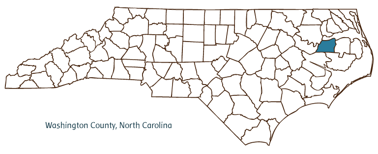
Washington County, located in the Coastal Plain region of North Carolina, was formed in 1799 from Tyrrell County and named for President George Washington. It is partially bordered by the Albemarle Sound. Early inhabitants of the area included Algonquian Indians, followed by English settlers. Plymouth, the county seat, was incorporated in 1807 and named for Plymouth, Mass. Other Washington County communities include Roper, Creswell, Cherry, Scuppernong, Pleasant Grove, Westover, Hinson, and Wenona. Besides Albemarle Sound, notable bodies of water in the county include the Roanoke and Scuppernong Rivers, Phelps and Pungo Lakes, Beaver Dam and Kendrick Creeks, and East Dismal Swamp. The Pocosin Lakes National Wildlife Refuge is located in the southeastern corner of the county.
Washington County historic sites include Garrett's Island Home, built in the mid-eighteenth century; Westover Plantation and Homestead Farm, both built in the mid-nineteenth century; and Somerset Place, built in the late eighteenth century and today a North Carolina State Historic Site. As a consequence of the Battle of Plymouth (1864), Confederate forces recaptured the town and reopened the Roanoke River. Cultural attractions include the Port O' Plymouth Roanoke River Museum and the Washington County Arts Council. The county hosts festivals and annual events such as Riverfest, Civil War Living History Weekend, Somerset Homecoming, Indian Heritage Week, and Plymouth Farm-City Festival.
Washington County agricultural products include corn, soybeans, peanuts, tobacco, cotton, cabbage, sage, beans, potatoes, hogs, and poultry. Manufactured products include wood pulp, paper, plywood, lumber, pallets, clothing, rope, and processed peanuts. Washington County's estimated population was 13,500 in 2004.
For an annotated history of the county's formation, with the laws affecting the county, boundary lines and changes, and other origin information, visit these references in The Formation of the North Carolina Counties (Corbitt, 2000), available online at North Carolina Digital Collections (note, there may be additional items of interest for the county not listed here):
County formation history: https://digital.ncdcr.gov/Documents/Detail/the-formation-of-the-north-ca...
Index entry for the county: https://digital.ncdcr.gov/Documents/Detail/the-formation-of-the-north-ca...
Additional resources:
Corbitt, David Leroy. The Formation of the North Carolina Counties, 1663-1943. Raleigh: Division of Archives and History, North Carolina Department of Cultural Resources, 1987. https://digital.ncdcr.gov/Documents/Detail/the-formation-of-the-north-carolina-counties-1663-1943/3692099?item=4553233 (accessed June 20, 2017).
Washington County Government. "Washington, North Carolina." https://washconc.org/ (accessed February 15, 2019).
Washington County Chamber of Commerce. http://www.chamberofwashingtoncounty.com/ (accessed February 15, 2019).
DigitalNC. "Washington County." North Carolina Digital Heritage Center. https://www.digitalnc.org/counties/washington-county/ (accessed February 15, 2019).
North Carolina Digital Collections. "Explore by ... [place, time period, format]." North Carolina Department of Natural and Cultural Resources. https://digital.ncdcr.gov (accessed February 15, 2019).
Image credits:
Rudersdorf, Amy. "NC County Maps." Raleigh: Government & Heritage Library, State Library of North Carolina, 2010.
Mazzocchi, Jay. "Washington County." NCpedia. State Library of NC. 2006. https://www.ncpedia.org/geography/washington.