Printer-friendly page

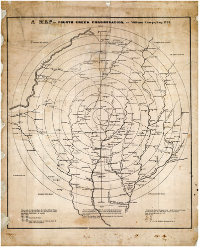
Map of Fourth Creek Congregation, Iredell County, North Carolina, published 1847, based on a map originally drawn by William Sharpe in 1773. From the collections of the State Archives of North Carolina.  Presented on NC Maps.

Exploring North Carolina: History of Maps, Surveying, Cartography and Cartographers

Background articles on Maps, Cartography, and Surveying of North Carolina

Maps
Surveyors
Cartographers
State Boundaries
Separtion of Carolinas
History of the Dividing Line
Preface to the North Carolina Gazetteer, 2nd. edition


North Carolina Surveyors, Cartographers & Mapmakers

Selected NCpedia articles

Brazier, Robert (d. 1837)

Mouzon, Henry Jr. (1741-1807)

Christmas, William (1753-1811)

Pearce, Samuel (1807-1878)

Churton, William  (1749-1767)

Price, Jonathan (d. 1822)

Collet, John Abraham (1756-1789)

Sauthier, Claude Joseph (1736-1802)

Lawson, John (1674-1711)

Sharpe, William (Laywer Billy) (1742-1818)

Masa, George (1882-1933)

Strother, John (d. 1815)

Maule, William (1690-1726)

Tatham, William (1752-1919)

Michel, Franz Ludwig (1680-post 1714)

White, John (b. 1540)

Moseley, Edward (1682-1749)

Wimble, James (fl. 1696-1744)

Listing of all entries for cartographers, mapmakers, and surveyors in NCpedia


Historical Map Depictions of North Carolina

NCpedia articles with links to historical maps

1585            John White: Map showing Roanoke Island and surrounding islands
1657            Nicholas Comberford: “The South Part of Virginia”
1671            John Ogilby: “A New Description of Carolina by Order of the Lords Proprietors”
1700-1710   John Brickell: "A Map of North Carolina"
1708            Herman Moll: "Carolina"
1709            John Lawson: “Lawson Map of North Carolina” 
1718            William Maule: Map of the ". . .Island of Roan-Oak. . ."
1733            Edward Moseley:  “New and Correct Map of the Province of North Carolina”
1737            Edward Moseley: “A New and Correct Map of the Province of North Carolina. . ."
1738            James Wimble: ". . .Chart of his Majesties Province of North Carolina. . ."
1770            John Collett:  "A Compleat Map of North Carolina”
ca. 1771      Claude Joseph Sauthier: “A Plan of the Camp and Battle of Alamance. . ."
1773            William Sharpe:  “A Map of Fourth Creek Congregation”
1775            Henry Mouzon and Others: “An Accurate Map of North and South Carolina. . .” 
1792            William Christmas: “Plan of Raleigh”
1798            W. Barker, Jonathan Price, and John Strother:  "A map of Cape Fear River. . ."
1808            Jonathan Price and John Strother: “First Actual Survey of the State of North Carolina”
1833            Robert H. B. Brazier (and John MacRae) “A New Map of the State of North Carolina”
1857            William Dewey Cooke and Samuel Pearce: “New Map of the State of North Carolina”
1860-1866  Samuel Pearce:  “Pearce’s New Map – The State of North Carolina” 

Additional map resources:

North Carolina Maps, UNC-Chapel Hill -- historical maps from the 1500s to 2000s. https://web.lib.unc.edu/nc-maps/index.php

Maps about Colonial Trade

Sugar in the Atlantic World. University of Michigan. https://web.archive.org/web/20190615205155/http://clements.umich.edu/exhibits/online/sugarexhibit/sugar05.php

The Triangular Trade. Map from the BBC Bitesize. https://www.bbc.co.uk/bitesize/guides/zqv7hyc/revision/3

Authors: 
From: