See also: The Way We Lived in North Carolina: Introduction; Part I: Natives and Newcomers, North Carolina before 1770; Part II: An Independent People, North Carolina, 1770-1820; Part III: Close to the Land, North Carolina, 1820-1870; Part IV: The Quest for Progress, North Carolina 1870-1920; Part V: Express Lanes and Country Roads, North Carolina 1920-2001
Early Coastal Towns

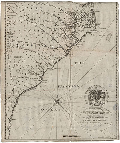
As colonists from Virginia first moved overland into the Albemarle region, other Englishmen and their enslaved African people began arriving by sea to establish settlements farther south. In the five years between 1662 and 1668, two separate expeditions would attempt to build towns in the Cape Fear region of North Carolina. Both would fail. For the remainder of the seventeenth century, and for the first quarter of the eighteenth, the European settlement of North Carolina would take place as it had started -- from the north. As land ran short in the Albemarle, colonists moved into the region around Pamlico Sound, and population centers developed in both regions. Before long, towns -- Edenton, Bath, New Bern, and Beaufort -- would dot the Carolina coastline.
Edenton, Bath, and Beaufort were settled primarily by Virginians and other colonists migrating south. One Pamlico region town, however, was established in a very different manner. In 1710 over 400 immigrants from the Swiss and German Palatinate arrived in the Pamlico region to establish the town of New Bern. Famine, war, religious unrest, and economic difficulties had forced thousands of Germans out of the upper Rhine Valley after 1708. Many migrated to London and were quickly identified as potential New World colonists. In 1710 a Swiss company planning a settlement in North Carolina turned to these refugees. Baron Christoph von Graffenried, a member and representative of the company, recruited several hundred hardy colonists from the refugees in London. After a transatlantic voyage and a difficult journey overland from the James River in Virginia, the Germans arrived at the junction of the Trent and Neuse Rivers in early September 1710. They were soon joined by a hundred impoverished Swiss immigrants. In 1711, a New Bern settler, Christen Janzen, described the area: "It is almost wholly forest, with indescribably beautiful cedar wood, poplars, oaks, beech, walnut and chestnut trees ... There is sassafras also, and so many other fragrant trees that I cannot describe the hundredth part. Cedar is red like the most beautiful cherry and smells better than the finest juniper. They are commonly, as well as the other trees, fifty to sixty feet below the limbs."
On the Albemarle Sound -- Edenton
The earliest of Carolina's immigrants to settle in a town clustered in the village of Roanoke—present-day Edenton—on the northwestern shore of Albemarle Sound. The commercial center of the Albemarle, Roanoke became the region's political center as well in 1710, when it became the capital of "that part of the Province of Carolina that lies North and East of Cape Fear." Renamed Queen Ann's Town in 1715, the town acquired its final name in 1722 when it was incorporated as Edenton, honoring the memory of Governor Charles Eden. William Byrd made this observation about Edenton in 1728: "They may be 40 or 50 Houses, most of them Small, and built without Expense. A Citizen here is counted extravagant, if he has Ambition enough to aspire to a Brick-chimney. Justice herself is but indifferently Lodged, the Court-House having much the Air of a Common Tobacco-House."
On the Pamlico River -- Bath

While Edenton was establishing itself as the commercial and political center of the Albemarle region, land-hungry settlers from Virginia were continuing their migration southward. Small commercial and political centers soon grew up in the Pamlico region. The earliest of the Pamlico centers was Bath Town. Incorporated in 1706, Bath is situated in present-day Beaufort County on the north bank of the Pamlico River. One of the first residents and commissioners of Bath was explorer-naturalist John Lawson. In February 1701, when Lawson completed his "thousand miles travel" through the Carolinas, he emerged from the backwoods within twenty miles of the town's future location. Lawson may have chosen the site for Bath Town; it is certain that he helped lay out the town before its incorporation.
On the Neuse River -- Beaufort
In 1706, while John Lawson and other colonists were founding Bath Town on the Pamlico River, settlements began springing up on the south side of the Neuse River. During the next two years, newcomers moved farther southeast toward Cape Lookout, into modern Carteret County, and constructed houses on the North and Newport Rivers. Between the two rivers, a narrow spit of land held obvious promise as a seaport. Well protected and easily accessible to the sea, the unnamed inlet drew the attention of the deputy surveyor of North Carolina in 1713, who drafted a "Plan of Beaufort Towne" that year. Named for the Duke of Beaufort, one of the eight Carolina proprietors, the town today bears much resemblance to its original design, and its street names -- Queen, Ann, Orange -- honor still the monarchs of the era.
Despite Beaufort's well-laid plans, the town grew little in its early years. North Carolina governor George Burrington wrote in 1731 that Beaufort had acquired "little success & scarce any inhabitants." A French visitor in 1765 found Beaufort "a Small village not above 12 houses." The "inhabitants seem miserable, they are very lasy and Indolent, they live mostly on fish and oisters, which they have in great plenty."