"How Did We Get Here from There?: Advances in North Carolina Transportation"
See also: History of Transportation for Students
Today, people rarely think twice about traveling to, from, or within North Carolina— whether by car, train, or airplane. Within hours a person can travel anywhere in the United States or in the world, for that matter. Time and distance have become compressed and standardized, and migration is no longer the ordeal of a hundred or even fifty years ago.
The earliest settlers arriving in present-day North Carolina and Virginia—several thousand years after the American Indians—came by ship across the Atlantic Ocean. Once Christopher Columbus made his voyage of 1492, people seeking new lives and adventures sought passage to the New World. They traveled on ships similar to the Elizabeth II, moored near Roanoke Island today. The average voyage from England to the coast of what is now North Carolina—a trip that a modern airplane can make in about seven hours—took approximately 2½ months (seventy-five days). Settlers moved slowly inward from the Outer Banks in search of more land.
By the late 1700s, North Carolina had a large economic base in its Coastal Plain and Piedmont, with settlements extending as far west as present-day Statesville, and migration moving toward present-day Tennessee. Ports operated from Edenton to Wilmington. Wagons and boats took imported goods to the inland areas. The Cape Fear, Chowan, Neuse, and Pamlico rivers moved goods from ships to cities. Wilmington, twenty miles inland from the mouth of the Cape Fear River, became the state’s main port by the early 1800s. The ports in the north were too shallow for larger ships and were phased out. At the same time, faster sailing ships were being developed to move cargo and passengers in record time. By the mid-1800s, steam replaced wind as the primary fuel source. For most of the Civil War, Wilmington served as one of the main Confederate ports for supplies. Today an occasional cruise ship will dock there to take passengers to the Caribbean and other ports of call.
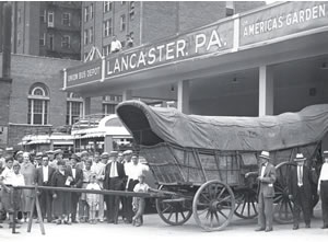
As the state grew, a road system between cities and towns developed. One of the earliest “highways” was the Great Philadelphia Wagon Road, which began in Pennsylvania and stretched south through North Carolina to Georgia. Construction varied from place to place, but the road largely was no more than a dirt path wide enough for wagons, with little or no protection against rain and mud. A family in Pennsylvania that wanted to move south sold off most of its possessions to pay for the trip, purchasing wagons, draft animals, food, and supplies. The main style of wagon used was the Conestoga, named for the part of Pennsylvania where it was built and possibly also for the Conestoga horses used to pull the wagons. A wagon could reach twenty-six feet in length and carry up to eight tons. Travel was slow, averaging fifteen to twenty-five miles a day. A trip from Lancaster, Pennsylvania, to Salisbury, for example, would take 24½ days, at an average of twenty miles a day, a distance of 490 miles. Southward migration down this road helped boost North Carolina’s population to 209,550 people in 1775, up from roughly 35,000 in 1730. The southern migration ended by the early 1800s, when people started looking to the American West for opportunity.
Improvements in North Carolina transportation, especially throughout the 1800s, mainly can be attributed to one person: Archibald D. Murphey. He was chairman of the Committee on Internal Improvements for the state senate in 1815. At the time, North Carolina lagged behind other states in road and waterway development. An illustration can be found in the writing of Francois Michaux, a foreign traveler who crossed the state in 1802. He found the roads and maps in western North Carolina so bad and rough that he not only feared getting lost but could not ride his horse for the terrain. He found better roads in the eastern region, though, around Fayetteville. Although Murphey’s committee could not predict all the advances to come in the following decades, it laid the groundwork for them. The committee focused on road improvement, canal and river construction to move goods along the coast, and better deepwater ports. From 1815 to 1860, North Carolina became one of the South’s leading states in terms of transportation.
All the migration and development of commerce focused attention on the most vital link—road condition and construction. By the early 1800s, roads were still nothing more than wide dirt paths. In rainy weather they turned to mud, while dry weather brought clouds of dust. Most roads had only one lane. When wagons met, one had to pull off the road to let the other pass. A new hard-surface road needed to be developed. From the 1830s through the 1850s, corduroy and plank roads vastly improved travel throughout the state. Plank roads consisted of hewed or planed boards, or trees cut square on both sides, placed side by side, giving wagons a smoother, more consistent surface than dirt. A corduroy road was built from logs placed side by side and then packed with dirt. Over time, the dirt (or sand) would erode, leaving a very bumpy ride for wagons! One interesting plank road fact related to its construction. Only the section leading into town was planked, leaving the other side the same old dirt road. The roads ensured that goods could be brought into market easily, but officials seemingly cared little about getting out. Plank roads and other improved roads could also be used as turnpikes, with property owners charging travelers a fee to cross their land. The owners could be made responsible for maintaining the section of road across their property, which meant maintenance varied greatly. Early routes of plank roads included Fayetteville to Salisbury, Charlotte to Lincolnton, and Wilmington to Holly Shelter (near Topsail Island). Fayetteville had five roads leading from it. Other main cities with plank routes included Charlotte, Taylorsville, and Asheville.
The plank road movement slowed, in part, due to one invention—the railroad steam locomotive. This new device, created from adapting steam boilers from ships, revolutionized the way goods were moved and people traveled across the United States.
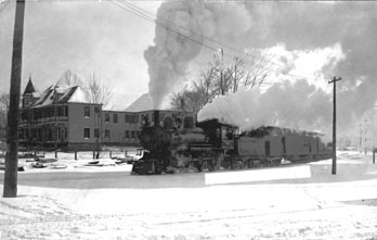
The first railroad in North Carolina was built in 1833 in downtown Raleigh to move granite blocks for the construction of the Capitol. Mules or horses pulled carts down the primitive track of what was known as the “Experimental Railroad.” Within a few years, the legislature was busy granting charters for new railroad construction, centered in the eastern region. The first chartered railroad to begin operation was the Wilmington and Raleigh, built between 1834 and 1840 and operated from Wilmington to Weldon, a distance of 161½ miles. At the time, it was considered the longest railroad in the world. Interestingly, though, Raleigh did not support the railroad when it was chartered, and the line actually ran through Goldsboro. Raleigh citizens soon changed their minds and allowed the building of the Raleigh and Gaston Railroad to begin in 1836. This line was completed from Lake Gaston on the Virginia border to downtown Raleigh in March 1840.
Railroads allowed people to travel much faster and farther on land. Locomotives could hit speeds of fifty miles an hour or more by the mid-1860s, and close to a hundred miles an hour by 1900. After the first transcontinental railroad was completed in 1869, a resident of North Carolina could travel by rail from Wilmington to Sacramento, California, in five to seven days. Other rail lines, including the North Carolina Railroad—built in the 1850s from Charlotte through Greensboro to Morehead City—allowed goods from the Piedmont to be transported to ports or to city markets.
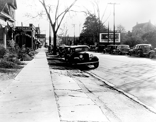
Another major travel improvement came with the development and construction of major highways. At the start of the 1900s, the automobile asserted its dominance. No longer did people have to rely on the schedules of the railroad or the rough ride of a horse-drawn carriage. A person could travel when and where he or she wanted. The remaining obstacle was the road system—still in some ways the same one built in the early 1800s. Newer hard-surface roads made of crushed seashells, early concrete, and crushed stone offered vast improvements. Since people wanted to travel to the same areas that the railroads did, new roads were built alongside tracks, causing a decline in railroad passenger business. The first highway to traverse the state stretched from Manteo, on the coast, to Murphy, along the Tennessee state line. The 1938 state road map listed these main early highways: Highway 17 (Elizabeth City–Wilmington); Highway 64 (Manteo– Murphy); Highway 70 (Atlantic–Asheville–Tennessee); and Highway 74 (Wilmington– Asheville). Along with others such as U.S. 1 and U.S. 301, these highways connected the states along the eastern seaboard. Most were of a hard surface like concrete and had two lanes.
As the number of cars increased, so did traffic. Congestion became a regular part of the highway system by the 1930s and 1940s. A new type of highway was planned in the 1950s: the interstate. Originally envisioned as a way to move military equipment across the country in times of war, it quickly became the futuristic way to travel long distances. President Dwight Eisenhower passed the new highway system into law in 1956, and construction began soon after. These new highways were open, usually had four lanes, and bypassed the centers of most cities. Off-ramp exits led to cities and towns. Higher speed limits decreased drive times. The first interstate built through North Carolina was Interstate 85, between the Raleigh-Durham area, Greensboro, and Charlotte. It was followed by Interstate 95 through Rocky Mount and Fayetteville, Interstate 40 between the Tennessee line and Wilmington, and Interstate 26 between Asheville and Spartanburg, South Carolina. Construction now is widening many interstates to eight lanes and even bypassing original routes to shorten trips.
One last major form of transportation—aviation—created one of the fastest ways to migrate. North Carolina helped start airplane travel when brothers Orville and Wilbur Wright made the first powered flight on December 17, 1903, in Kill Devil Hills. By the 1930s, the Douglas DC-3 had revolutionized airline travel, and companies (including Eastern Airlines) flew into Raleigh, Winston-Salem, and Charlotte. In 1948 Piedmont Airlines, based in Winston-Salem, made its first flight from Wilmington to Cincinnati, Ohio. From that point, many cities in North Carolina, large and small, could offer flights to destinations throughout the state and country. Piedmont Airlines made the first direct flight (of eight hours) from North Carolina to London, England, on June 15, 1987, and five months later started a direct service to Nassau, Bahamas. Today, one can take direct or connecting flights to almost anywhere in the world.
Migration clearly has become faster and easier. That early trip from Lancaster, Pennsylvania, to Salisbury, has changed from a 24½-day trip by wagon (1790s) to thirteen hours by rail (1940s), to 7½ hours by car (Interstate, 1970s), to 4½ hours by plane (today). With all the speed of modern travel, though, missing is the relaxing feel of a country road or the clickety-clack of a railroad—seeing the scenery and history of North Carolina, not just wondering how many more miles or hours to the destination.
At the time of the publication of this article, Larry K. Neal Jr. is the manager of visitor services at the North Carolina Transportation Museum in Spencer. Many of the types of transportation mentioned in this article are displayed throughout the museum. To learn more, visit http://www.nctrans.org/