Related entries: North Carolina's three regions, Coastal Plain, Piedmont, Mountains
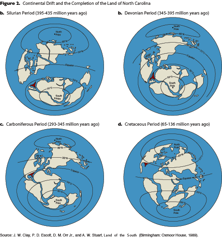
The geologic processes that formed this landscape have operated over a span of at least 1.2 billion years and have involved massive shifts in the plates that make up the earth’s crust (Figure 2). About one billion years ago the eastern margin of North America was situated where the Blue Ridge Mountains are today. To the the east lay a wide ocean containing island arcs and micro-continents that were moving as the plates they rested on shifted. Beginning about 450 million years ago, the island arcs and micro-continents began to collide with, and add on to, eastern North America. These collisions generated heat and pressure that thrust the rocks up into great mountain ranges, often associated with the injection of molten magma into subterranean chambers and volcanic eruptions.
The last major mountain building event was the result of Africa colliding with North America about 300 million years ago. The energy from this collision was so great that a mountain range the size of the present Himalayas was built. The effects of the collision can be seen in the folded rocks as far west as central Tennessee. The eroded debris from those mountains built the widespread deposits of the Appalachian Plateau that extends across Kentucky as far west as Cincinnati.

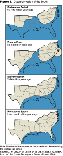
The supercontinent formed by the collision of North America and Africa is known as Pangea and it persisted for about 100 million years. Pangea began to stretch apart about 225 million years ago and, by 200 million years ago, the Atlantic Ocean began to open. With the opening of the Atlantic Ocean, the Coastal Plain began to form. It is constructed mainly from the sediments that eroded from the nearby mountains and carried to the shore by rivers. These sediments were deposited in alluvial, coastal and shallow marine environments as the ocean invaded far inland (Figure 3). With time, these deposits built eastward, constructing an enormous wedge-shaped deposit of sediments and sedimentary rocks. The top of the sedimentary wedge is nearly flat while the base of the wedge increases from zero thickness along its inland margin to more than 10,000 feet under Cape Hatteras. Offshore, the wedge reaches a maximum thickness of 30,000 feet and begins to taper once more toward the ocean floor. The rocks within the wedge dip gently eastward and progressively younger deposits can be seen on an eastward traverse across the Coastal Plain.
During the long interval of the construction of the sedimentary wedge, sea level fluctuated many times. On occasion the shoreline was situated at least as far inland as the Fall Line (Figure 3). At other times the shoreline was located farther east, at the edge of the continental shelf. Some of these fluctuations in sea level are recorded by terraces on the Coastal Plain, where the eroded edge of a terrace represents a temporary shoreline. About 18,000 years ago, sea level dropped as much as 400 feet below its current level. This drop was caused by the growth of continental glaciers in North America, Europe and Asia. As the glaciers grew, they removed vast quantities of water from the world’s oceans. With the end of the Ice Age, the glaciers have largely melted and returned pent-up waters to the oceans, causing sea level to rise once again. Sea level continues to rise today at a rate of about six inches per century.
The current geology of the state is the result of these episodes of continental collisions, mountain building, fluctuations in sea level and erosion. While this land may seem constant to the human observer, it is in fact a very dynamic situation that is changing constantly, albeit slowly.