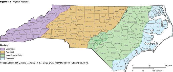
The three landforms of North Carolina make up the three major geographic regions of the state: the Coastal Plain, the Piedmont, and the Mountains. The Coastal Plain Region is usually divided into two sub regions: the Outer Coastal Plain, commonly referred to as the Tidewater; and the Inner Coastal, which is less impacted by the effects of the ocean as it is located further inward.

North Carolina regions by county

North Carolina Counties - Click to see a large version
Click to see a large version

View the list of North Carolina counties.

North Carolina physical regions

Physical boundaries that divide the regions


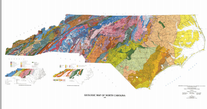
Link to 1985 Geologic Map of North Carolina.  From North Carolina Department of Environment and Natural Resources.
Link to 1985 Geologic Map of North Carolina. From North Carolina Department of Environment and Natural Resources.


Sources:

"Geography of North Carolina," North Carolina Department of Public Instruction, https://www.dpi.nc.gov (accessed March 26, 2012).

Raisa, E. 1940. Landforms of the United States. Reprinted in The North Carolina Atlas Revisited.

NCDENR. 1985 Geologic Map of North Carolina (links to a number of maps). http://portal.ncdenr.org/web/lr/1985-state-geologic-map (accessed September 2, 2015).

Additional Resources:

North Carolina One Map. North Carolina Imagery Portal. https://www.nconemap.gov/pages/imagery (accessed September 2, 2015).

Image Credits:

North Carolina Geological Survey. Geologic map of North Carolina: North Carolina Geological Survey, General Geologic Map. 1985. http://portal.ncdenr.org/web/lr/1985-state-geologic-map (accessed September 2, 2015).


Citation

"Our State Geography in a Snap: Three Regions Overview." NCpedia. NC Department of Public Instruction. Accessed on January 10th, 2025. https://ncpedia.org/our-state-geography-snap-three.