Jackson County Resources
- View All:
- Biographies
- Monuments
- locations
ANCHOR (A North Carolina History Online Resource) is now its own website!
Copyright Notice: This article is from the Encyclopedia of North Carolina edited by William S. Powell. Copyright © 2006 by the University of North Carolina Press. Used by permission of the publisher. For personal use and not for further distribution. Please submit permission requests for other use directly to the publisher.
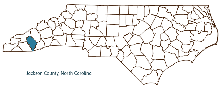
Jackson County, located in North Carolina's Mountain region, was formed from Haywood and Macon Counties in 1851, taking its name from President Andrew Jackson. Webster served as the county seat until 1913, when it was moved to Sylva (incorporated in 1889). Other communities in the county include Dillsboro, Cullowhee, Cashiers, Glenville, Balsam, Tuckasegee, and parts of Highlands, Cherokee, and Sapphire. Jackson County also contains part of the Qualla Boundary, the reservation of the Eastern Band of Cherokee Indians. Natural features important to the area include Judaculla Rock, with Indian markings of ancient origin, and Ellicott Rock, a boundary landmark.
Bordering both South Carolina and Georgia in the extreme southwestern portion of North Carolina, Jackson County's location in the Great Smoky Mountains has ensured a vibrant tourist industry. Skiing and hiking opportunities are available, while the Tuckasegee River is renowned among enthusiasts of whitewater rafting and trout fishing. The Great Smoky Mountains Railroad, operating out of Dillsboro, offers a variety of scenic day trips, and the county also boasts no fewer than 16 waterfalls. Despite significant population growth during the 1990s, Jackson County remains heavily wooded-most of its area lies within the Nantahala National Forest, and lumber and Christmas trees are an important source of revenue. The town of Cullowhee is home to Western Carolina University and the North Carolina Center for the Advancement of Teaching, the first state-funded program in the nation dedicated to the professional development of public school teachers. The estimated population of Jackson County in 2004 was 35,600.
For an annotated history of the county's formation, with the laws affecting the county, boundary lines and changes, and other origin information, visit these references in The Formation of the North Carolina Counties (Corbitt, 2000), available online at North Carolina Digital Collections (note, there may be additional items of interest for the county not listed here):
County formation history: https://digital.ncdcr.gov/Documents/Detail/the-formation-of-the-north-ca...
Index entry for the county: https://digital.ncdcr.gov/Documents/Detail/the-formation-of-the-north-ca...
References:
The History of Jackson County (1987).
Additional resources:
Corbitt, David Leroy. 2000. The formation of the North Carolina counties, 1663-1943. https://digital.ncdcr.gov/Documents/Detail/the-formation-of-the-north-carolina-counties-1663-1943/3692099?item=4553233 (accessed June 20, 2017).
Jackson County Government: https://www.jacksonnc.org/
Jackson County Chamber of Commerce: https://www.mountainlovers.com/
DigitalNC, Jackson County: https://www.digitalnc.org/counties/jackson-county/
North Carolina Digital Collections (explore by place, time period, format): https://digital.ncdcr.gov
Image credits:
Rudersdorf, Amy. 2010. "NC County Maps." Government & Heritage Library, State Library of North Carolina.
Vocci, Robert Blair. "Jackson County." NCpedia. Library of NC. 2006.
JACKSON COUNTY GOVERNMENT:
https://www.jacksonnc.org/
COUNTY SEAT: Sylva
FORMED: 1851
FORMED FROM: Haywood, Macon
LAND AREA: 490.76 square miles
2020 POPULATION ESTIMATE: 43,109
White: 85.2%
Black/African American: 2.4%
American Indian: 9.1%
Asian: 1.1%
Pacific Islander: <0.1%
Two or more races: 2.2%
Hispanic/Latino: 6.2% (of any race)
From State & County QuickFacts, US Census Bureau, 2020.
CONGRESSIONAL DISTRICT: 11TH
BIOGRAPHIES FOR![]()
Jackson County
 WILDLIFE PROFILES FOR
Mountain region
GEOGRAPHIC INFORMATION
REGION: Mountain
RIVER BASIN: Little Tennessee, Savannah, Map
NEIGHBORING COUNTIES: Haywood, Macon, Swain, Transylvania