Duplin County Resources
- View All:
- Biographies
- Monuments
- locations
ANCHOR (A North Carolina History Online Resource) is now its own website!
Copyright Notice: This article is from the Encyclopedia of North Carolina edited by William S. Powell. Copyright © 2006 by the University of North Carolina Press. Used by permission of the publisher. For personal use and not for further distribution. Please submit permission requests for other use directly to the publisher.
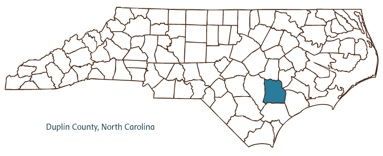
Duplin County, located in the Coastal Plain region of North Carolina, was formed in 1750 from New Hanover County and named for Thomas Hay, Lord Duplin, a member of the English Board of Trade and Plantations. Early inhabitants of the area included the Tuscarora and Siouan Indians, followed by English, Swiss, Scotch-Irish, and German settlers. Kenansville, the county seat, was incorporated in 1852 and named for James Kenan, one of the town's founders. Other communities in the county include Beulaville, Calypso, Magnolia, Rose Hill, Wallace, and Warsaw. Notable physical features of the county include the Northeast Cape Fear River, Muddy Creek, Bear Swamp, Maxwell Mill Pond, and Picadilly Bay.
Duplin County boasts several historic attractions, among them the Kenansville Historic District, with notable examples of Greek Revival architecture, and the Dickson Farm, dating from the early nineteenth century. Kenansville is the site of Liberty Hall Plantation, ancestral home of the Kenan family. County cultural institutions include the Cowan Museum (a collection of unusual American artifacts), the William Rand Kenan Memorial Amphitheatre, and the Tar Heel Fine Arts Society. The Duplin Winery is the oldest winery in North Carolina, established in the 1960s. The county also hosts many annual festivals and events, such as the Warsaw Veterans Day Celebration (the nation's oldest continuously celebrated Veterans Day event), the North Carolina Pickle Festival, the North Carolina Poultry Jubilee, and Beach Music at the Winery.
Agriculture is a key part of the Duplin County economy, and goods produced include tobacco, cotton, cucumbers, strawberries, corn, soybeans, wheat, barley, sweet potatoes, Christmas trees, turkeys and other poultry, hogs, and beef and dairy cattle. Manufactured products include textiles, pickles, apparel, and frozen foods. Duplin County's population was estimated to be 51,500 in 2004.
For an annotated history of the county's formation, with the laws affecting the county, boundary lines and changes, and other origin information, visit these references in The Formation of the North Carolina Counties (Corbitt, 2000), available online at North Carolina Digital Collections (note, there may be additional items of interest for the county not listed here):
County formation history: https://digital.ncdcr.gov/Documents/Detail/the-formation-of-the-north-ca...
Index entry for the county: https://digital.ncdcr.gov/Documents/Detail/the-formation-of-the-north-ca...
References:
Leon H. Sikes, Duplin County Places, Past and Present: A Guide to Duplin County, North Carolina (1984).
Additional resources:
Corbitt, David Leroy. 2000. The formation of the North Carolina counties, 1663-1943. https://digital.ncdcr.gov/Documents/Detail/the-formation-of-the-north-carolina-counties-1663-1943/3692099?item=4553233 (accessed June 20, 2017).
Duplin County Government: https://www.duplincountync.com/
Duplin County Economic Development Commission: https://www.duplinedc.com/
DigitalNC, Duplin County: https://www.digitalnc.org/counties/duplin-county/
North Carolina Digital Collections (explore by place, time period, format): https://digital.ncdcr.gov
Image credits:
Rudersdorf, Amy. 2010. "NC County Maps." Government & Heritage Library, State Library of North Carolina.
Mazzocchi, Jay. "Duplin County." NCpedia. Library of NC. 2006.
DUPLIN COUNTY GOVERNMENT:
https://www.duplincountync.com/
COUNTY SEAT: Kenansville
FORMED: 1750
FORMED FROM: New Hanover
LAND AREA: 816.22 square miles
2020 POPULATION ESTIMATE: 48,715
White: 70.4%
Black/African American: 25.5%
American Indian: 1.4%
Asian: 0.7%
Pacific Islander: 0.4%
Two or more races: 1.6%
Hispanic/Latino: 23.0% (of any race)
From State & County QuickFacts, US Census Bureau, 2020.
CONGRESSIONAL DISTRICT: 7TH
BIOGRAPHIES FOR![]()
Duplin County
 WILDLIFE PROFILES FOR
Coastal Plain
GEOGRAPHIC INFORMATION
REGION: Coastal Plain
RIVER BASIN: Cape Fear, Map
NEIGHBORING COUNTIES: Jones, Lenoir, Onslow, Pender, Sampson, Wayne


