Columbus County Resources
- View All:
- Biographies
- Monuments
- locations
ANCHOR (A North Carolina History Online Resource) is now its own website!
Copyright Notice: This article is from the Encyclopedia of North Carolina edited by William S. Powell. Copyright © 2006 by the University of North Carolina Press. Used by permission of the publisher. For personal use and not for further distribution. Please submit permission requests for other use directly to the publisher.
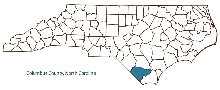
Columbus County, located in the Coastal Plain region of southeastern North Carolina, was formed in 1808 from Brunswick and Bladen Counties and named for explorer Christopher Columbus. It partially borders the state of South Carolina. Early inhabitants of Columbus County include the Waccamaw Indians, followed by English, French, and Scottish settlers. The county seat, Whiteville, was incorporated in 1832 and named for James B. White, who was the first state senator from Columbus County; he also donated the land for the county courthouse in 1808. Other communities in Columbus County are Acme-Delco, Brunswick, Fair Bluff, and Tabor City.
Among Columbus County agricultural products are corn, soybeans, sweet potatoes and Irish potatoes, catfish, pecans, peanuts, beef and dairy cattle, and poultry. Manufactured products include textiles, plywood, doors, windows, furniture, and a variety of tools.
Lake Waccamaw State Park is Columbus County's premier natural attraction. Naturalists John and William Bartram made extensive visits to the Lake Waccamaw area in the eighteenth century and recorded their experiences. Green Swamp is another important natural landmark, representing a unique environment with many animal and plant species. Historic sites in the county include the Robert E. Lee Brown House, built in 1910, and the Snowden Singletary House, dating from the early nineteenth century. Cultural institutions include the Columbus County Theatre Association, the Cultural Arts Center, and the Fair Bluff Historical Society. Whiteville is also home to an extension of the North Carolina Museum of Natural Sciences. Popular annual events include the North Carolina Yam Festival, the Strawberry Festival, and the Columbus Chorus Christmas Concert. About 1,800 members of the Waccamaw-Siouan tribe continue to live in Columbus and Bladen Counties. The total population of Columbus County was estimated to be 54,500 in 2004.
For an annotated history of the county's formation, with the laws affecting the county, boundary lines and changes, and other origin information, visit these references in The Formation of the North Carolina Counties (Corbitt, 2000), available online at North Carolina Digital Collections (note, there may be additional items of interest for the county not listed here):
County formation history: https://digital.ncdcr.gov/Documents/Detail/the-formation-of-the-north-ca...
Index entry for the county: https://digital.ncdcr.gov/Documents/Detail/the-formation-of-the-north-ca...
Additional resources:
Corbitt, David Leroy. 2000. The formation of the North Carolina counties, 1663-1943. https://digital.ncdcr.gov/Documents/Detail/the-formation-of-the-north-carolina-counties-1663-1943/3692099?item=4553233 (accessed June 20, 2017).
Columbus County Government: https://columbusco.org/
DigitalNC, Columbus County: https://www.digitalnc.org/counties/columbus-county/
North Carolina Digital Collections (explore by place, time period, format): https://digital.ncdcr.gov
Image credits:
Rudersdorf, Amy. 2010. "NC County Maps." Government & Heritage Library, Library of North Carolina.
Mazzocchi, Jay. "Columbus County." NCpedia. Library of NC. 2006.
COLUMBUS COUNTY GOVERNMENT:
https://columbusco.org/
COUNTY SEAT: Whiteville
FORMED: 1808
FORMED FROM: Brunswick, Bladen
LAND AREA: 937.29 square miles
2020 POPULATION ESTIMATE: 50,623
White: 63.1%
Black/African American: 30.6%
American Indian: 3.8%
Asian: 0.5%
Pacific Islander: 0.1%
Two or more races: 1.9%
Hispanic/Latino: 5.6% (of any race)
From State & County QuickFacts, US Census Bureau, 2020.
CONGRESSIONAL DISTRICT: 7TH
BIOGRAPHIES FOR![]()
Columbus County
 WILDLIFE PROFILES FOR
Coastal Plain
GEOGRAPHIC INFORMATION
REGION: Coastal Plain
RIVER BASIN: Lumber, Map
NEIGHBORING COUNTIES: Bladen, Brunswick, Pender, Robeson


