Brunswick County Resources
- View All:
- Biographies
- Monuments
- locations
ANCHOR (A North Carolina History Online Resource) is now its own website!
Copyright Notice: This article is from the Encyclopedia of North Carolina edited by William S. Powell. Copyright © 2006 by the University of North Carolina Press. Used by permission of the publisher. For personal use and not for further distribution. Please submit permission requests for other use directly to the publisher.
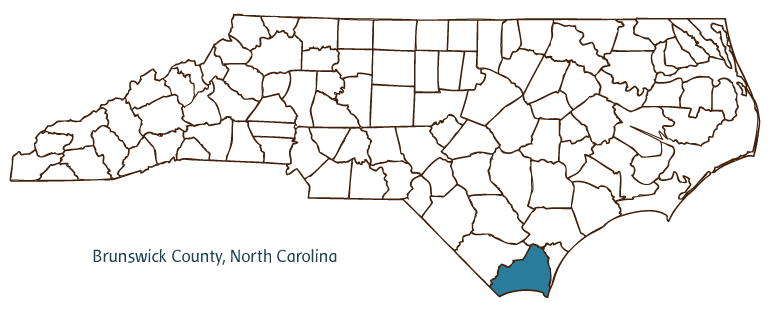
Brunswick County, located in the Coastal Plain region of southeastern North Carolina, was formed in 1764 from New Hanover and Bladen Counties. The county was named after King George I, who was also the duke of Brunswick and Lunenburg. Early inhabitants of Brunswick County included the Cape Fear Indians, followed by English and French Huguenot settlers. The county seat is now (since 1975) Southport,[*] but for most of the county's history, Bolivia (incorporated in 1911) served in that role. Situated along the Atlantic Coast, Brunswick County has some of North Carolina's most accessible and popular ocean communities, including Sunset Beach, Ocean Isle Beach, Holden Beach, and Bald Head Island. Cape Fear lies at the southern tip of Bald Head Island, and the Cape Fear River runs along the county's eastern border. The Intracoastal Waterway passes through the county as well.
Brunswick County is home to a number of historic sites, including Orton Plantation and Gardens, dating to ca. 1730; Bald Head Island Lighthouse, fondly known as "Old Baldy"; and the Brunswick Inn, built in 1859. Fort Johnston, completed in 1764, served as a refuge for royal governor Josiah Martin in 1775. Brunswick Town/Fort Anderson State Historic Site interprets the colonial and Civil War history of the region. Other cultural institutions include the Southport Maritime Museum, the Brunswick County Historical Society, and the Bald Head Island Conservatory. Well-attended annual events in Brunswick County include the North Carolina Fourth of July Festival, the Christmas-by-the-Sea Festival, the North Carolina Festival-by-the-Sea, and the North Carolina Oyster Festival.
Brunswick County agricultural products include tobacco, vegetables, berries, corn, oats, sweet potatoes, swine, beef cattle, and poultry; and manufactured products include polyester fibers, children's clothes, lumber, and citric acid. In addition to the beaches that draw millions of vacationers, the county's numerous golf courses are a popular attraction for visitors (as well as a growing number of retirees). Charter boat fishing on the Intracoastal Waterway is another important recreational activity in the region. Brunswick County's population was estimated to be 85,000 in 2004.
For an annotated history of the county's formation, with the laws affecting the county, boundary lines and changes, and other origin information, visit these references in The Formation of the North Carolina Counties (Corbitt, 2000), available online at North Carolina Digital Collections (note, there may be additional items of interest for the county not listed here):
County formation history: https://digital.ncdcr.gov/Documents/Detail/the-formation-of-the-north-ca...
Index entry for the county: https://digital.ncdcr.gov/Documents/Detail/the-formation-of-the-north-ca...
*NOTE: the county seat of Brunswick is once again Bolivia.
References:
Lawrence Lee, The History of Brunswick County, North Carolina (1980).
David Stick, Bald Head: A History of Smith Island and Cape Fear (1985).
Additional resources:
Corbitt, David Leroy. 2000. The formation of the North Carolina counties, 1663-1943. https://digital.ncdcr.gov/Documents/Detail/the-formation-of-the-north-carolina-counties-1663-1943/3692099?item=4553233 (accessed June 20, 2017).
Brunswick County Government: http://www.brunswickcountync.gov/
Brunswick County Chamber of Commerce: https://brunswickcountychamber.org/
DigitalNC, Brunswick County: https://www.digitalnc.org/counties/brunswick-county/
North Carolina Digital Collections (explore by place, time period, format): https://digital.ncdcr.gov
Image credits:
Rudersdorf, Amy. 2010. "NC County Maps." Government & Heritage Library, State Library of North Carolina.
Powell, William S. "Brunswick County." NCpedia. Library of NC. 2006.
BRUNSWICK COUNTY GOVERNMENT:
http://www.brunswickcountync.gov/
COUNTY SEAT: Bolivia
FORMED: 1764
FORMED FROM: New Hanover, Bladen
LAND AREA: 846.97 square miles
2020 POPULATION ESTIMATE: 136,693
White: 86.5%
Black/African American: 10.0%
American Indian: 0.8%
Asian: 0.7%
Pacific Islander: 0.1%
Two or more races: 1.8%
Hispanic/Latino: 4.9% (of any race)
From State & County QuickFacts, US Census Bureau, 2020.
CONGRESSIONAL DISTRICT: 7TH
BIOGRAPHIES FOR![]()
Brunswick County
 WILDLIFE PROFILES FOR
Coastal Plain
GEOGRAPHIC INFORMATION
REGION: Coastal Plain
RIVER BASINS: Cape Fear, Lumber, Map
NEIGHBORING COUNTIES: Columbus, New Hanover, Pender


