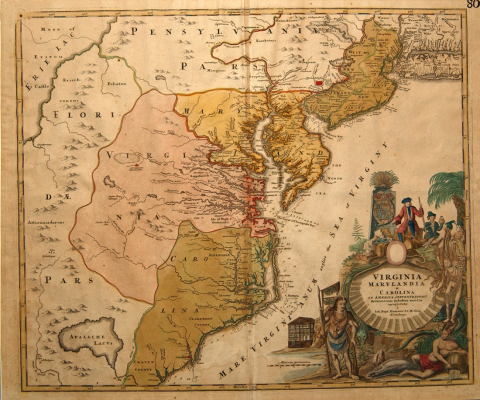
Circa 1714 map of Maryland, Virginia, and Carolina
Johann Baptist Homann's hand-colored engraved map Virginia Marylandia et Carolina... was first published in a 1714 atlas, and was re-published numerous times thereafter. The map depicts Homann's interpretation of the American colonies as they existed in the early part of the 18th century. The geographical range extends south from Pennslyvania, New York, and New Jersey to South Carolina; and west to Lake Erie and the Appalachian mountains. Important cities and towns are marked in red: Philadelphia, in Pennsylvania; what is simply called "Carolina," on the Cape Fear River in Carolina; and "Germantown/Teutsche Statt," in Virginia. Flordia, which belonged to Spain at the time, spans the western edge of the map. A large but fictitious Appalachian lake appears in the mountains in Florida. This non-existent geographical feature was likely based on earlier maps of the region. The Atlantic Ocean is labeled the Sea of Virginia. A cartouche in the bottom right corner depicts Europeans trading with Indians.
All Rights Reserved
"All rights reserved" is a traditional copyright term that indicates that the copyright holder reserves for his/her/their own use all of the rights given to copyright owners under U.S. copyright law. Items that are included in NCpedia and/or ANCHOR with this rights statement appear by agreement or permission from the rights holder or the institution that holds the item. Click "Available at" to visit the website for the collection where the item appears for more information about the rights or specific uses allowed. For all other non-specified uses, please contact the copyright holder or item owner.