Printer-friendly page

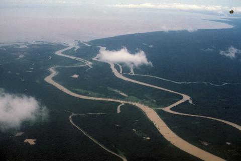
Aerial view of Mekong River joining Tonle Sap Lake near Siem Reap

Aerial view of Mekong River joining Tonle Sap Lake near Siem Reap

This view photographed from an airplane shows where the Mekong River joins Tonlé Sap Lake near Siem Reap in Cambodia. The waterways of the Mekong are the region's primary conduit for local trade and transportation.

The Mekong River flows approximately 2,800 miles from the high plateaus of Tibet to the fertile delta regions now within southern Vietnam and Cambodia. The rich river delta soils allow up to three crops of rice per year and form the major food-producing regions of both countries.

<img typeof="foaf:Image" src="http://statelibrarync.org/learnnc/sites/default/files/images/vietnam_181.jpg" width="1024" height="683" alt="Aerial view of Mekong River joining Tonle Sap Lake near Siem Reap" title="Aerial view of Mekong River joining Tonle Sap Lake near Siem Reap" />
Usage Statement: 

Creative Commons BY-NC-SA

This item has a Creative Commons license for re-use.  This Creative Commons BY-NC-SA license means that you may use, remix, tweak, and build upon the work for non-commerical purposes as long as you credit the original creator and as long as you license your new creation using the same license. For more information about Creative Commons licensing and a link to the license, see full details at https://creativecommons.org/licenses/by-nc-sa/4.0/.