Avery County Resources
- View All:
- Biographies
- Monuments
- locations
ANCHOR (A North Carolina History Online Resource) is now its own website!
Copyright Notice: This article is from the Encyclopedia of North Carolina edited by William S. Powell. Copyright © 2006 by the University of North Carolina Press. Used by permission of the publisher. For personal use and not for further distribution. Please submit permission requests for other use directly to the publisher.
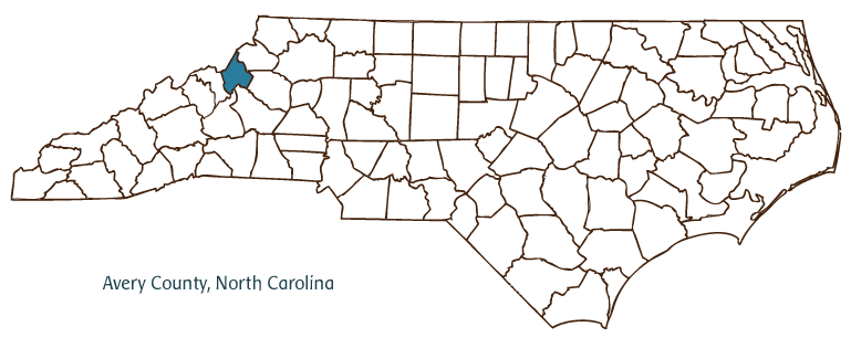
Avery County, located in North Carolina's Mountain region and bordered in part by Tennessee, was formed in 1911 from parts of Mitchell, Caldwell, and Watauga Counties. Avery was the one-hundredth and final county to be created in North Carolina. The county was named after Col. Waightstill Avery, a Revolutionary War officer and the first attorney general of North Carolina. The earliest inhabitants of Avery County were the Cherokee Indians, followed by German, Scotch-Irish, and English settlers. Newland, the county seat, was incorporated in 1913 and named for William Calhoun Newland, the lieutenant governor of North Carolina from 1909 to 1913. Newland is situated at an elevation of 3,589 feet, making it the highest county seat in the eastern United States. Other communities in Avery County include Banner Elk, Crossnore, Elk Park, and Linville. Lees-McRae College was established in Banner Elk in 1900.
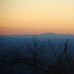
The terrain of Avery County is perhaps its most significant feature and is the basis for its primary industry, tourism. Located in a region known as the "High Country," it is a very popular destination for vacationers, including hikers, hang gliders, and other outdoor enthusiasts, who flock to the county throughout the year, particularly in the fall and summer, to enjoy the rugged beauty of the region. Several important landmarks draw thousands of other visitors, including the much-visited Grandfather Mountain, Linville Caverns, and Beech Mountain. The Blue Ridge Parkway's Linn Cove Viaduct, a 1,234-foot curved bridge near Grandfather Mountain, represents one of the most complex engineering feats in the United States. Major events such as the Grandfather Mountain Highland Games, Beech Mountain Storytelling and Crafts Festival, and Banner Elk Art Festival are some of Avery County's most popular annual attractions.
Avery County produces lumber, tobacco, potatoes, and beef cattle. It has been called a "Christmas tree capital" for its supplying of large numbers of the popular Fraser fir variety of tree used for this purpose (and now the official state Christmas tree). The county also produces such minerals as kaolin, mica, iron, and feldspar. In 2004 Avery County's population was estimated to be 18,000.
For an annotated history of the county's formation, with the laws affecting the county, boundary lines and changes, and other origin information, visit these references in The Formation of the North Carolina Counties (Corbitt, 2000), available online at North Carolina Digital Collections (note, there may be additional items of interest for the county not listed here):
County formation history: https://digital.ncdcr.gov/Documents/Detail/the-formation-of-the-north-ca...
Index entry for the county: https://digital.ncdcr.gov/Documents/Detail/the-formation-of-the-north-ca...
Additional resources:
Corbitt, David Leroy. 2000. The formation of the North Carolina counties, 1663-1943. https://digital.ncdcr.gov/Documents/Detail/the-formation-of-the-north-carolina-counties-1663-1943/3692099?item=4553233 (accessed June 20, 2017).
Avery County Government: https://www.averycountync.gov/
Avery County Chamber of Commerce: https://averycounty.com/
DigitalNC, Avery County: https://www.digitalnc.org/counties/avery-county/
North Carolina Digital Collections (explore by place, time period, format): https://digital.ncdcr.gov
Image credits:
Rudersdorf, Amy. 2010. "NC County Maps." Government & Heritage Library, Library of North Carolina.
Mazzocchi, Jay. "Avery County." NCpedia. Library of NC. 2006.
AVERY COUNTY GOVERNMENT:
https://www.averycountync.gov/
COUNTY SEAT: Newland
FORMED: 1911
FORMED FROM: Mitchell, Watauga, Caldwell
LAND AREA: 247.09 square miles
2020 POPULATION ESTIMATE: 17,806
White: 92.9%
Black/African American: 4.7%
American Indian: 0.6%
Asian: 0.6%
Pacific Islander: 0.1%
Two or more races: 1.1%
Hispanic/Latino: 5.1% (of any race)
From State & County QuickFacts, US Census Bureau, 2020.
CONGRESSIONAL DISTRICT: 5TH
BIOGRAPHIES FOR![]()
Avery County
 WILDLIFE PROFILES FOR
Mountain region
GEOGRAPHIC INFORMATION
REGION: Mountain
RIVER BASIN: Catawba, French Broad, Watauga, Map
NEIGHBORING COUNTIES: Burke, Caldwell, McDowell, Mitchell, Watauga