The boundaries of each round town are detailed in town charters in the various volumes of North Carolina laws. For instance, the boundaries of the Chatham County town of Goldston, incorporated in 1907, were "a radius of one-half mile from the depot of the Southern Railway Company at Goldston." The town limits of Newland, incorporated in 1913, were "120 rods" from the Avery County Courthouse. The Northampton County town of Milwaukee, incorporated in 1915, fixed its town limits at a one-mile radius from the center of the crossroads in the town.
Other landmarks used by round towns to set boundaries include a railroad bridge (Waco, incorporated in 1907) and the center of the local high school building (Boiling Springs, in Cleveland County, incorporated in 1911 but no longer a round town). The town limits of Bear Grass, incorporated in Martin County in 1909, were "all that territory within a radius of five hundred yards from a certain white oak on the east side of the public road, near a well at the stores of Rogers Brothers and Cowing Brothers."
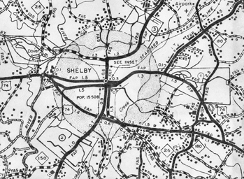
One of North Carolina's early round towns was the Cleveland County seat of Shelby, incorporated by an act of the General Assembly in 1843. The original town boundary formed a circle with a quarter-mile radius, beginning at the courthouse. In 1901 the town limits were increased to a radius of three-quarters of a mile from the courthouse and in 1928 increased again to a radius of a mile and a half. Shelby remained a round town until the annexation of a development in 1957, which altered its circular shape. Several later annexations added more "bumps" to the town limits. By 1976 the city council had begun changing the town limits to conform with property lines, but Shelby's boundaries still contained traces of its days as a round town.
Round towns are also found in Indiana, Georgia, and Mississippi, states to which many North Carolinians emigrated in antebellum times.