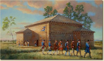
Fort Dobbs, located in present-day Statesville, was a defensive fort built in 1756 under the auspices of North Carolina's colonial Assembly during the French and Indian War. The large log fort, deemed necessary for the protection of frontier settlers during the conflict, was constructed by provincial rangers under the command of Hugh Waddell and named for royal governor Arthur Dobbs. Waddell and his rangers manned the fort and used it as a base of operations during the conflict. At times colonists stayed close to the fort's walls for protection. The fort was actually attacked by Cherokee Indians only once, on the night of 27 Feb. 1760, resulting in the deaths of one or two of Waddell's men and as many as 12 Cherokees.
After the Treaty of Paris ended the war, Fort Dobbs was no longer essential to the protection of the colonists, who had seen the boundary of British settlement move farther west through the defeat of the Cherokees. The fort was dismantled, and its buildings eventually fell into disrepair. Archaeologists have determined the exact location of the fort, although its appearance remains unclear. The modern Fort Dobbs State Historic Site allows visitors to view the remains of the fort and also features displays of artifacts, trails, archaeological sites, a gift shop, and recreation facilities.