See also: Blossom's Ferry; Cape Fear and Deep River Steam Navigation Company; Ferries; Steamboats; Albemarle Steam Navigation Company; Yadkin River Navigation Company; Tar River Navigation Company; Dan River Steam Navigation Company; Neuse River Navigation Company; New River Navigation Company; Deep and Haw River Navigation Company
In the centuries before railroad and motor transportation, North Carolina's rivers provided valuable travel routes. But accidents of geography severely limited the potential of river travel in the region. Sandbars and sunken logs obstructed many coastal plain rivers, and piedmont rivers contained not only these obstacles but also rocks, rapids, and waterfalls. The Outer Banks, pierced only by shifting and shallow inlets, blocked the sounds from the ocean. This lack of direct access to the ocean limited the value of even the most navigable stretches of coastal rivers. Of these, the Chowan and the Roanoke Rivers empty into the Albemarle Sound, and the Tar-Pamlico and Neuse Rivers empty into the Pamlico Sound. The White Oak and New Rivers flow into the Atlantic, but they are small and offer little access to the interior. The Cape Fear River, formed by the Deep and Haw Rivers in the piedmont, empties directly into the Atlantic and has given the state access from much of the interior to the ocean. Navigation was made more difficult by wild fluctuations in water level, as rivers were vulnerable to prolonged droughts as well as floods. From colonial days until the steamboat era, river travel was easiest when water levels were high during the winter and often was halted completely during dry summers.
Despite less-than-ideal conditions, early explorers and settlers managed to use rivers to great advantage. English explorers pressed deep into North Carolina by way of the Roanoke and Chowan Rivers in 1586. The Cape Fear River gave passage to Spanish settlers under Lucas Vasquez de Ayllon in 1526 and English settlers in the 1660s, although neither colony was successful. Virginian settlers observed Saura (Cheraw) Indian tribes on the Dan River in the late 1600s, later finding others on Drowning Creek, which would become the Lumber River in Robeson County. (The Lumbee Indians remain centered around the Lumber, now a national Wild and Scenic River noted for animal life.) Other settlers from western Virginia staked out lands along rivers that flowed into Albemarle Sound beginning in the 1650s; others later followed the Neuse, Pamlico, Tar, and Cape Fear Rivers. The long navigable stretches of the Cape Fear and its tributaries encouraged a thriving trade in produce and naval stores through the ports of Brunswick and Wilmington.
Because they gave access to transportation, lands along navigable rivers were usually the first to be settled. Colonial laws provided for a number of public landings to allow residents entry to rivers. North Carolina's early towns-Bath, Beaufort, New Bern, Edenton, Brunswick, Wilmington, and others-were located by navigable streams. In addition, rivers divided the state into small regions based on river valleys. Because of poor road conditions, these valleys offered no easy access to other regions of the state, and rapids and waterfalls at the fall line, where the level of the land drops between piedmont and coastal plain, divided inhabitants into eastern and western factions. The limited usefulness of rivers as trade routes retarded agricultural, industrial, economic, and cultural growth; encouraged isolation and sectionalism; and contributed to the backwardness of the state and the high rates of emigration during the early nineteenth century.
Early settlers in the piedmont found their rivers to be more barriers than highways. Most rivers in this region are relatively small, and many are interrupted by rocks and rapids or waterfalls. Of the major rivers in the piedmont, the Dan flows into Virginia before uniting with the Roanoke and winding back into North Carolina, and the Catawba and the Yadkin-Pee Dee begin in the mountains and flow into South Carolina. Although of limited use for navigation, the piedmont rivers became valuable sources of waterpower-first in running gristmills, then in operating cotton mills and other factories, and finally in powering hydroelectric projects. Although often grand and beautiful, the mountain rivers were too shallow and rocky to be of much use as travel routes. Many of them also have been harnessed to provide electric power.
Following the American Revolution, particularly in the first half of the nineteenth century, North Carolina undertook a program of internal improvements to enhance its economy, an important facet of which was to improve the navigability of watercourses. During and after the colonial era, the legislature empowered the county courts to order the clearing of navigable rivers and streams within their jurisdictions. From the Revolution to the Civil War, however, the General Assembly often addressed specific waterways, mandating the county courts to require mill owners to provide slips for the passage of boats and occasionally appointing individuals to clear streams. Generally those efforts were unproductive.
Beginning in 1815, the General Assembly deemed the promotion of internal improvements so important that it instituted the practice of buying stock in several companies on behalf of the state. In the 1840s it renewed its attempts to improve river navigability by chartering more companies and investing additional state funds in these organizations. The state acquired stock in reincorporated Neuse and Yadkin companies and in the New River Navigation Company in Onslow County. The legislature reserved its major investment for the Cape Fear and Deep River Navigation Company, eventually buying the company, which proved to be a disappointment. The Roanoke and the Cape Fear remained the only successful navigation companies, at least to the extent that they remained afloat and paid dividends throughout the antebellum era. The difficulty of the undertakings, lack of engineering expertise, scarcity of labor, adverse weather conditions, and damaging freshets generated by heavy rains undermined many promising operations.
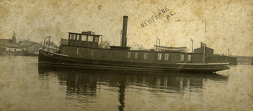
Ferries have carried passengers across North Carolina's rivers since at least 1699. Early ferries were wooden flats usually guided across a stream by a cable. The cable could be lowered into the stream to permit other boats to pass. Today, the state maintains free ferry service across several rivers, ranging from large ferries that cross the Neuse, Pamlico, and Cape Fear Rivers to small, two-car ferries, such as the one at Sans Souci on the Cashie River in Bertie County.
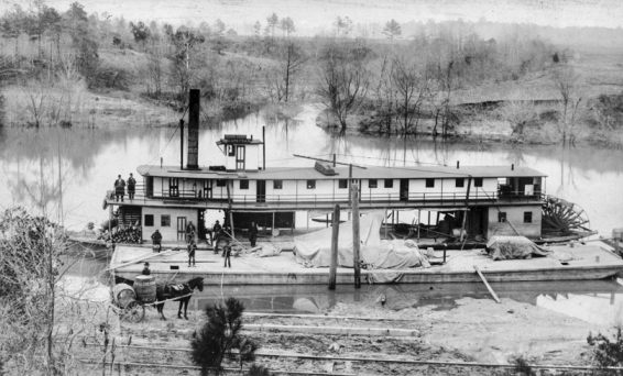
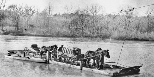
By the late nineteenth century, boats powered by gasoline or diesel engines began to replace steamboats. Commercial river travel in North Carolina declined significantly, pressed by competition from railroads and later from automobiles and trucks on the expanding network of paved roads in the state. Half a century later, passenger service on the rivers (except for ferries) was long a thing of the past. Commercial river business consisted of hauling bulk cargoes such as logs, fertilizer, oil, farm products, pulpwood, and fish. Barges towed by motor vessels still carry bulk cargoes on some rivers in the coastal plain, and Wilmington, 30 miles up the Cape Fear River from the Atlantic, remains the state's major port. North Carolina's rivers are now seen less as highways than as an important part of the environment, crucial for their role in supporting wildlife and providing drinking water. Many residents and tourists seek out these rivers for recreation, fishing, or simply to appreciate their natural beauty and their role in history.